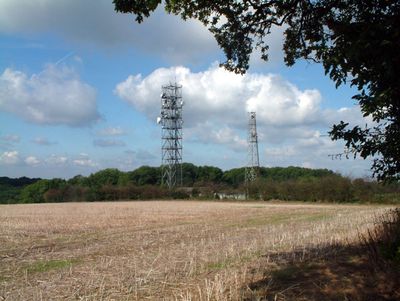
Tatsfield Receiving Station, BBC radio monitoring facility in Surrey, England
Tatsfield Receiving Station is a BBC radio monitoring facility on the North Downs, equipped with multiple masts and technical apparatus for capturing broadcast signals. The site was designed to receive and measure radio frequencies across a wide range of international broadcasts.
The facility began operations in September 1929 as a broadcast monitoring post. Its role expanded during World War II when it was tasked with tracking enemy propaganda and foreign broadcasts across Europe and Asia.
The station played a key role in British radio monitoring, helping to oversee international broadcast frequencies and ensure signal quality across the country. Visitors can see how such facilities were central to managing the nation's radio communications.
The site sits roughly 15 miles (24 kilometers) southeast of central London on elevated terrain. Access is limited and visitors should check current conditions before attempting to view or explore the grounds.
In October 1957, the station became the first in Britain to detect radio signals from the Soviet satellite Sputnik 1. This achievement shows just how sensitive and capable the equipment was during the earliest days of space exploration.
Inception: September 1929
GPS coordinates: 51.29000,0.01000
Latest update: December 14, 2025 17:43
Barrow Green Court
4.1 km
Titsey Place
1.5 km
All Saints Church, Oxted
3.4 km
Saltbox Hill
3.9 km
Woldingham & Oxted Downs
3.4 km
Westerham Wood
3.9 km
St Mark's Church
3 km
Church of St James the Greater
1.6 km
Church of St Paul
3.3 km
Church of St Peter
3.2 km
Church of St Mary the Virgin
1.5 km
Church of St Mary the Virgin
3.7 km
Church of St Leonard
3 km
Cottage Orne Attached To Spinning Wheel Restaurant
3.3 km
Biggin Hill Memorial Column
3.3 km
Everyman Oxted
3.8 km
Norheads Farmhouse
2.8 km
Oxted War Memorial Cross
3.9 km
United Reformed Church and Attached Walls
3.4 km
Water trough near Biggin Hill War Memorial at the junction of Jail Lane and Main Road
3.4 km
Limpsfield War Memorial
3.3 km
Whitelake Tomb 1 Yard East Of Chancel
3.7 km
Building 33 (Station Headquarters)
4.1 km
Court Farm House
3.7 km
Chest Tomb 3 Yards North East Of Corner Of Chancel
3.7 km
Milestone, half mile E of Oxted viaduct, 70m W of jct with Detillens Lane
3.7 km
Oxted Viaduct
4 km
Milestone, Redwood, 400m E of village; by entrance to Redwood
3.7 kmVisited this place? Tap the stars to rate it and share your experience / photos with the community! Try now! You can cancel it anytime.
Discover hidden gems everywhere you go!
From secret cafés to breathtaking viewpoints, skip the crowded tourist spots and find places that match your style. Our app makes it easy with voice search, smart filtering, route optimization, and insider tips from travelers worldwide. Download now for the complete mobile experience.
A unique approach to discovering new places❞
— Le Figaro
All the places worth exploring❞
— France Info
A tailor-made excursion in just a few clicks❞
— 20 Minutes