Grovely Castle, Iron Age hillslope fort in Steeple Langford, England
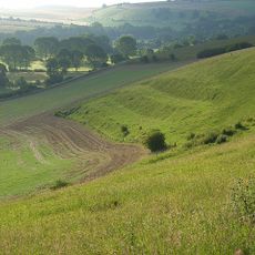
Grovely Castle is an Iron Age hilltop fortification in Steeple Langford, Wiltshire. The site consists of multiple concentric earthen ramparts and ditches that define a sizable defended area still clearly visible across the landscape today.
The fort was constructed during the Iron Age as a defensive settlement for the local population. Archaeological work at the site has revealed evidence of occupation across multiple phases of development.
The site contains evidence of an extensive Celtic field system, marked by a bank and ditch that intersects the fort from southwest to northeast.
The site is accessible on foot from multiple directions and open to explore at any time. The hilltop position offers clear views across the surrounding fields and valleys.
Aerial photography has revealed a circular structure hidden within the fort's interior that is difficult to spot from ground level. This concealed feature raises questions about its exact purpose and significance.
Location: Steeple Langford
Part of: Grovely Castle and earthworks N of Grovely Wood
GPS coordinates: 51.12126,-1.93196
Latest update: December 14, 2025 17:40
Ebsbury
1.5 km
Church of St Nicholas Of Mira
843 m
Church of St Mary
2.7 km
Church of All Saints
2.1 km
Grovely Castle and earthworks N of Grovely Wood
18 m
Cottage To North Of Tudor Cottage
3.2 km
Steeple Langford
2.5 km
Pembroke Cottage With Attached Boundary Wall
2.2 km
Fern Cottage
2 km
Manor Farm Cottage
2.7 km
Danvers Cottage
2.7 km
Greystone Cottage
1.9 km
Milepost In Front Of Southington Cottages
1.6 km
Southington
2.3 km
Milepost In Drive To East Of Clyffe Farm
1.6 km
The Manor House
2.2 km
Swaynes With Attached Stable Block
2 km
Milestone About 200 Metres South Of Royal Oak Inn
3 km
Stable To Wishford Farm At Rear Of Beehive House
3.1 km
Little Langford Model Farm
565 m
The Parsonage
2.7 km
Great Wishford Church Of England School
3.2 km
Bankside
2.7 km
Grovely Lodge
1.8 km
Milepost, Warminster Road; Stapleford; 300m S jcn B3083
2.5 km
Barn To South Of Old Rectory
2 km
Milestone, Crouch's Down; 10m S current track on field boundary
3.1 km
Milestone, between The Rookery & The Lawn; 400m S boundary pig farm
3 kmVisited this place? Tap the stars to rate it and share your experience / photos with the community! Try now! You can cancel it anytime.
Discover hidden gems everywhere you go!
From secret cafés to breathtaking viewpoints, skip the crowded tourist spots and find places that match your style. Our app makes it easy with voice search, smart filtering, route optimization, and insider tips from travelers worldwide. Download now for the complete mobile experience.
A unique approach to discovering new places❞
— Le Figaro
All the places worth exploring❞
— France Info
A tailor-made excursion in just a few clicks❞
— 20 Minutes