Pixieland, Family amusement park in Dartmoor, United Kingdom
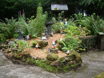
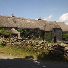
Pixieland is an amusement park in Dartmoor with multiple themed areas, rides, play zones, and picnic spots distributed across the grounds. The facility sits within Dartmoor National Park and merges children's entertainment with on-site craft production of garden figures.
The park was founded in 1947 and from the start combined garden gnome manufacturing with family entertainment in the Dartmoor area. This blend of craft production and leisure activity has defined the place since its opening.
Garden gnomes are made here using original 1947 molds, and visitors can see the craftspeople working on-site to create these figures by hand. This connects the park to a specific regional craft tradition that people can actually watch and understand.
The park operates with hours that shift with the seasons, and free parking is available for all visitors. It is useful to check opening times in advance, especially if you plan to visit during winter months.
The park still uses the original 1947 production molds to make its garden gnomes, a handmade process that has become rare elsewhere. Visitors can witness an old manufacturing technique that has largely disappeared from other places.
GPS coordinates: 50.54611,-3.88222
Latest update: December 14, 2025 18:20
Dunnabridge Pound
2.4 km
Church of St Raphael
661 m
Ponsworthy Bridge
3.4 km
Hexworthy Or Huccaby Bridge
1 km
Forder Bridge
3.3 km
Forder Cottages (The Pair Immediately West Of The Splash)
3.3 km
Higher Uppacott Uppacott
3.4 km
County Bridge Stone Set Into Garden Wall Of Ponsworthy House About 5 Metres North East Of Its South Gate
3.5 km
Ringleshutes tinwork
3.7 km
Foxworthy Farmhouse
2.8 km
Clapper Bridge About 20 Metres North Of Dartmeet Bridge
545 m
Clapper Bridge At Sx 672749
1.5 km
Cairns N of Corndon Tor
2.3 km
Lt E. A. Cave-Penney Memorial Cross
1.6 km
Clapper bridge about 60 metres south east of West Shallowford Farmhouse
3.2 km
Partially enclosed stone hut circle settlement 350m south west of Horn's Cross
2.7 km
Horn's Cross
2.5 km
Wayside cross on Down Ridge 1.1km south west of Saddle Bridge
2.5 km
Hexworthy Farmhouse
1.5 km
Barn Approximately 10 Metres To South-East Of Dunnabridge Pound Farmhouse
2.5 km
Wayside cross on Down Ridge 730m south west of Saddle Bridge
2.3 km
Blowing house and mill at Gobbet
2.3 km
Ouldsbroom Cross
1.7 km
Pigsty About 30 Metres South East Of Sweaton Farmhouse
3.3 km
Blowing houses at Week Ford
1.3 km
Blowing house on Down Ridge
3 km
Milestone, Sherberton Common, below Corndon Down, at slow bends between crossways, 400m SW of Lock's Gate
2.3 km
Milestone, 100m E of entrance to Brimpts Farm
147 mVisited this place? Tap the stars to rate it and share your experience / photos with the community! Try now! You can cancel it anytime.
Discover hidden gems everywhere you go!
From secret cafés to breathtaking viewpoints, skip the crowded tourist spots and find places that match your style. Our app makes it easy with voice search, smart filtering, route optimization, and insider tips from travelers worldwide. Download now for the complete mobile experience.
A unique approach to discovering new places❞
— Le Figaro
All the places worth exploring❞
— France Info
A tailor-made excursion in just a few clicks❞
— 20 Minutes