Enable Location

We need your location to show you interesting places around you

Discover nearby places

Find interesting locations and hidden gems around you

Precise directions

Get accurate directions and distances to places

Your location is never shared with other users. It's only used when you tap the location button.

Gathurst Viaduct

Log in to your account

Start exploring — it's free

Trusted by 62,921 travelers worldwide

Continue with Google
Continue with Apple
or

We will send you a code to connect

By continuing, you accept our Terms and Conditions and our Privacy Policy

Check your inbox

We've sent a pincode in your inbox. Please enter the code below.

Gathurst Viaduct
Discussion Reviews 1 Photos
2.1k Popularity

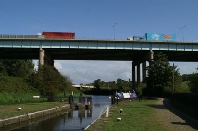
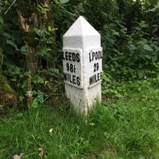
Gathurst Viaduct, Motorway bridge in Wigan, England

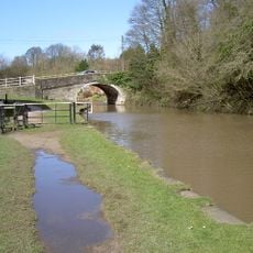
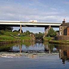
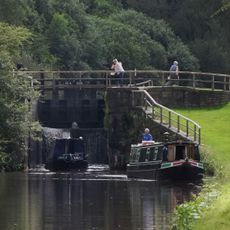
Gathurst Viaduct is a concrete bridge carrying the M6 motorway across Douglas Valley while allowing the Leeds and Liverpool Canal and railway lines to pass underneath. The structure spans across the landscape using continuous welded steel plate girders supported by large concrete pillars.

The viaduct opened in December 1961 as part of the expanding British motorway network, connecting communities across the valley. Its completion marked a turning point in post-war infrastructure development.

The structure represents the engineering achievements of post-war Britain, connecting communities while maintaining passage for canal boats and trains below.

The viaduct sits between junctions 26 and 27 of the M6 and is visible from the valley below, making it easy to see its scale and construction from ground level. Best views come from nearby rest areas and roads that run underneath or alongside the bridge.

The bridge features ten continuous welded plate girders extending its full length, supported by five sets of four concrete columns measuring 1.8 meters in diameter.

The community of curious travelers

AroundUs brings together thousands of curated places, local tips, and hidden gems, enriched daily by 60,000 contributors worldwide.

Start exploring
GPS coordinates
53.56170,-2.70090
Latest update
December 13, 2025 17:04
Around this place
Standish Hall
United Kingdom

Standish Hall

2.5 km
Church of St Thomas the Martyr, Up Holland
United Kingdom

Church of St Thomas the Martyr, Up Holland

2.7 km
St John the Divine's Church, Pemberton
United Kingdom

St John the Divine's Church, Pemberton

3 km
Upholland Priory
United Kingdom

Upholland Priory

2.8 km
Church of St Andrew
United Kingdom

Church of St Andrew

3.5 km
Church of St James and Presbytery
United Kingdom

Church of St James and Presbytery

3.7 km
Church of St Joseph and Attached Presbytery
United Kingdom

Church of St Joseph and Attached Presbytery

3.5 km
The Springfield Public House
United Kingdom

The Springfield Public House

3.6 km
Hesketh Arms Public House And Adjacent Mounting Block
United Kingdom

Hesketh Arms Public House And Adjacent Mounting Block

3.2 km
Cross Base Opposite End Of Westmead
United Kingdom

Cross Base Opposite End Of Westmead

3.4 km
Leeds And Liverpool Canal Milestone Approximately 30 Metres South East Of Hand Lane Bridge
United Kingdom

Leeds And Liverpool Canal Milestone Approximately 30 Metres South East Of Hand Lane Bridge

3.4 km
St Barnabas Church, Marsh Green
United Kingdom

St Barnabas Church, Marsh Green

2.5 km
St Anne's Church, Shevington
United Kingdom

St Anne's Church, Shevington

1.4 km
Boundary walls and gateways to west and south of Church of St John the Divine
United Kingdom

Boundary walls and gateways to west and south of Church of St John the Divine

3 km
St Marie Of The Annunciation War Memorial Cross
United Kingdom

St Marie Of The Annunciation War Memorial Cross

3.2 km
Gathurst Bridge
United Kingdom

Gathurst Bridge

382 m
Up Holland War Memorial
United Kingdom

Up Holland War Memorial

2.4 km
Ashurst's Beacon
United Kingdom

Ashurst's Beacon

3.6 km
Leeds And Liverpool Canal Dean Locks
United Kingdom

Leeds And Liverpool Canal Dean Locks

131 m
Giant's Hall Farmhouse
United Kingdom

Giant's Hall Farmhouse

3 km
Leeds And Liverpool Canal Southern Lock At Appley Locks
United Kingdom

Leeds And Liverpool Canal Southern Lock At Appley Locks

2.8 km
Cross Base Outside Number 108
United Kingdom

Cross Base Outside Number 108

3.3 km
Cross Base In Bank
United Kingdom

Cross Base In Bank

2.9 km
Former Pemberton Library
United Kingdom

Former Pemberton Library

3.7 km
Leeds And Liverpool Canal Hand Lane Bridge (Number 41)
United Kingdom

Leeds And Liverpool Canal Hand Lane Bridge (Number 41)

3.4 km
56, Wigan Road
United Kingdom

56, Wigan Road

3.6 km
Ackhurst Hall
United Kingdom

Ackhurst Hall

1.1 km
Wrightington  Hall
United Kingdom

Wrightington Hall

3.2 km
Show the full map
Reviews
Share your experience

No review yet

Discussions
Start a discussion...

No discussion yet

« Gathurst Viaduct - Motorway bridge in Wigan, England » is provided by Around Us (aroundus.com). Images and texts are derived from Wikimedia project under a Creative Commons license. You are allowed to copy, distribute, and modify copies of this page, under the conditions set by the license, as long as this note is clearly visible.

Discover hidden gems everywhere you go!

From secret cafés to breathtaking viewpoints, skip the crowded tourist spots and find places that match your style. Our app makes it easy with voice search, smart filtering, route optimization, and insider tips from travelers worldwide. Download now for the complete mobile experience.

Around Us App Screenshot

A unique approach to discovering new places

Le Figaro

All the places worth exploring

France Info

A tailor-made excursion in just a few clicks

20 Minutes

Around Us
Travel Guide & Maps
Download

Send to your phone

QR Code
1

Open the camera app on your mobile.

2

Point at the QR code with your camera. A notification will appear.

3

Tap the notification to open the link.