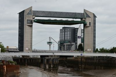
Tidal Surge Barrier, River Hull, Flood barrier in Kingston upon Hull, England
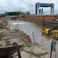
The River Hull Tidal Surge Barrier is a concrete structure with two towers housing a rotating gate system roughly 30 meters wide and 26 meters high. The installation closes and lowers to the riverbed during high tides to stop water from flowing inland into homes and streets.
Built in response to severe flooding in 1969, the barrier opened in 1980 and became part of the city's long-term flood protection strategy. Since then, it has proven essential for managing tidal risks in the region.
This structure shows how local communities have adapted to living with tidal risks through engineering. It represents the practical way residents depend on modern defenses to keep their city safe from water.
The barrier is easy to view from public footpaths along the river, with good vantage points from both banks. Visit during high tide or when surge conditions are forecast to see the gates in operation.
The structure holds Grade II listed status despite being a flood defense system, a rare recognition that gives it heritage protection. This classification reflects its engineering design and contribution to the city's character.
Location: City of Kingston upon Hull
GPS coordinates: 53.74000,-0.33126
Latest update: December 9, 2025 18:45
The Deep
162 m
Hull Minster
277 m
Scale Lane Bridge
284 m
Humber Street Gallery
253 m
Dinostar
167 m
Statue of Andrew Marvell on North Side of South Church Side
338 m
Equestrian statue of William III
195 m
Hepworths Arcade
300 m
Minerva Hotel
331 m
Public Toilets To North Of King William Iii Statue
200 m
Former Corporation Pier Station
259 m
Ye Olde Black Boy Public House
307 m
Pillar Box Outside Number 40
335 m
The Market Hall And Bob Carvers Fish And Chip Restaurant
326 m
Wool Exchange
310 m
5, Scale Lane
281 m
K1 Telephone Kiosk In Market Hall
323 m
Electric Street Lamp At South West Corner Of Holy Trinity Churchyard
323 m
9, Market Place
299 m
Building Between Kings Market And Wool Exchange
298 m
4 5 And 6, Silver Street
334 m
Former Pilot Office
220 m
Central Dry Dock/ Sand Southend Wharf
79 m
153, High Street
327 m
Public Conveniences, Nelson Street
297 m
Statue of William de-la-Pole
234 m
Kings Market
277 m
Old Grammar School Museum
324 mVisited this place? Tap the stars to rate it and share your experience / photos with the community! Try now! You can cancel it anytime.
Discover hidden gems everywhere you go!
From secret cafés to breathtaking viewpoints, skip the crowded tourist spots and find places that match your style. Our app makes it easy with voice search, smart filtering, route optimization, and insider tips from travelers worldwide. Download now for the complete mobile experience.
A unique approach to discovering new places❞
— Le Figaro
All the places worth exploring❞
— France Info
A tailor-made excursion in just a few clicks❞
— 20 Minutes