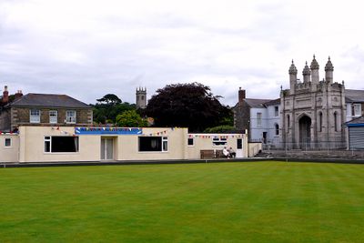
Helston Castle, Medieval castle ruins in Helston, Cornwall, England
The castle site now features a bowling green and the Grylls Monument at the base of Coinagehall Street in central Helston.
Edmund, 2nd Earl of Cornwall, commissioned the construction of Helston Castle in the late 13th century as part of his extensive regional holdings.
The castle location forms part of the Heritage Trail, which connects numerous historical landmarks throughout the medieval stannary town of Helston.
Visitors can obtain information about the castle site from the Museum of Cornish Life, which maintains records of the medieval structure.
William of Worcester documented the castle's ruined state in 1478 with the Latin inscription 'Castellum Helston dirutum' in his travel notes.
Location: Helston
GPS coordinates: 50.10000,-5.27778
Latest update: December 20, 2025 11:40
The Flambards Experience
1.7 km
Helston Town Hall
267 m
Helston Museum
279 m
Museum of Cornish Life
275 m
Church of St Michael
390 m
Milestone, Culdrose, end of RNAS Culdrose runway/golf course
1.4 km
Helston Library
454 m
Milestone Approximately 309M East Of Gwealdues Hotel
1.8 km
Godolphin Club
374 m
Monument To H M Grylls
56 m
1 Cross Street and 50 Church Street
348 m
Wayside cross and cross slab in St Michael's churchyard
378 m
Penberthy Tombs And Cross Approximately 8 Metres West Of Church Of St Michael
378 m
Schoolhouse On North Side Of Former National School
371 m
Two K6 Telephone Kiosks Adjacent To Guildhall
275 m
Guide Post At Junction With Squires Lane
1.5 km
Bridge To East Of Penrose Manor House
2.1 km
Helston Lodge
2 km
Guide Post At Junction With Gipsy Lane
1.6 km
Gun From Hms Anson In Central Position Behind Guildhall
271 m
Schoolhouse On South Side Of Former National School
359 m
Trenethick Barton Farmhouse
2.1 km
Steps, Railings, Gate Piers And Cross To South East Of Church Of St Michael
380 m
Guide Post At Sw 640282
1.9 km
Sundial Approximately 20 Metres South Of West End Of Church Of St Michael
367 m
The Willows And Attached Forecourt Walls And Railings
344 m
Stone cross near junction with Church Street
334 m
Milestone, Lower Laanner, E of bridge
1.9 kmVisited this place? Tap the stars to rate it and share your experience / photos with the community! Try now! You can cancel it anytime.
Discover hidden gems everywhere you go!
From secret cafés to breathtaking viewpoints, skip the crowded tourist spots and find places that match your style. Our app makes it easy with voice search, smart filtering, route optimization, and insider tips from travelers worldwide. Download now for the complete mobile experience.
A unique approach to discovering new places❞
— Le Figaro
All the places worth exploring❞
— France Info
A tailor-made excursion in just a few clicks❞
— 20 Minutes