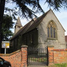
St Everilda's Church, Nether Poppleton, Medieval Anglican church in Nether Poppleton, England.
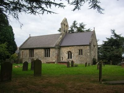
St Everilda's Church is a medieval stone building in this village with square-headed windows in the nave and ornate glazed windows from the 14th century in the chancel. The structure underwent significant reconstruction in the twelfth century and gained a modern extension in 2015 that includes kitchen areas for community gatherings.
An early building at this site was documented in 1088 when its right of patronage passed to the Benedictine monastery of St Mary's Abbey in York. The current church emerged from comprehensive reconstruction during the twelfth century, which shaped its form and character through the centuries.
The church's dedication to Saint Everilda reflects a rare connection to Anglo-Saxon religious history that shaped this local community. Walking through the nave, visitors sense how a name linked to an ancient religious figure has remained woven into the village's identity.
Visiting the church can happen on different days, with access and opening times potentially varying by season. It is advisable to check current access arrangements before your visit to avoid any inconvenience.
Only two churches in England bear the name of Saint Everilda, making this building a rare dedication that sets it apart. This unusual dedication often surprises visitors who encounter a lesser-known saint not commonly found in parish churches.
The community of curious travelers
AroundUs brings together thousands of curated places, local tips, and hidden gems, enriched daily by 60,000 contributors worldwide.