Enable Location

We need your location to show you interesting places around you

Discover nearby places

Find interesting locations and hidden gems around you

Precise directions

Get accurate directions and distances to places

Your location is never shared with other users. It's only used when you tap the location button.

Feldkommandostelle Hochwald

Log in to your account

Start exploring — it's free

Trusted by 62,001 travelers worldwide

Continue with Google
Continue with Apple
or

We will send you a code to connect

By continuing, you accept our Terms and Conditions and our Privacy Policy

Check your inbox

We've sent a pincode in your inbox. Please enter the code below.

Feldkommandostelle Hochwald

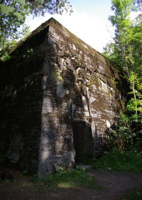
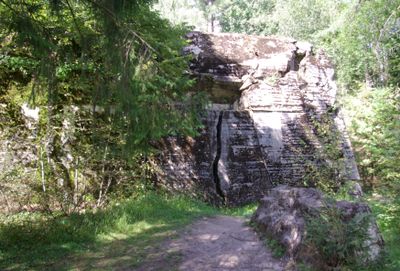
Feldkommandostelle Hochwald, Military command post in Pozezdrze, Poland

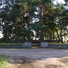
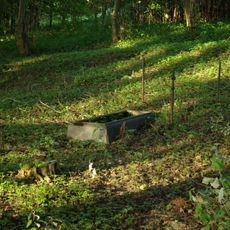
Feldkommandostelle Hochwald is a reinforced concrete fortification located in a forested area near Pozezdrze. The structure contains interconnected underground and surface chambers that once housed command rooms and protective bunkers for military operations.

This facility was built in 1941 under Organization Todt supervision and served as a command center during military operations in the region. It played a key role in coordinating field activities and maintaining communications during the conflict.

The complex represents wartime military engineering through its reinforced concrete construction methods and specialized defensive design principles.

The site is located in a wooded area and requires some effort to explore all parts of the installation. Visitors should wear appropriate footwear and be aware that some sections may be uneven or slippery.

The facility employed advanced camouflage methods using wire mesh covered with artificial leaves in shades of green, yellow, and brown. This technique was designed to completely conceal the structure from aerial view and protect it from reconnaissance.

The community of curious travelers

AroundUs brings together thousands of curated places, local tips, and hidden gems, enriched daily by 60,000 contributors worldwide.

Start exploring
GPS coordinates
54.14972,21.85361
Latest update
December 9, 2025 18:44
Around this place
Węgorzewo Castle
Poland

Węgorzewo Castle

10 km
Church of SS. Peter and Paul in Węgorzewo
Poland

Church of SS. Peter and Paul in Węgorzewo

10.1 km
Kościół Dobrego Pasterza w Węgorzewie
Poland

Kościół Dobrego Pasterza w Węgorzewie

10.3 km
Holy Cross church in Węgorzewo
Poland

Holy Cross church in Węgorzewo

10.3 km
Church of the Assumption of Virgin Mary in Kruklanki
Poland

Church of the Assumption of Virgin Mary in Kruklanki

8.1 km
Rezerwat przyrody Piłackie Wzgórza
Poland

Rezerwat przyrody Piłackie Wzgórza

8.2 km
Saints Peter and Paul Orthodox church in Węgorzewo
Poland

Saints Peter and Paul Orthodox church in Węgorzewo

10.5 km
Saint Demetrius Orthodox church in Kruklanki
Poland

Saint Demetrius Orthodox church in Kruklanki

8.1 km
Maximilian Kolbe church in Kuty
Poland

Maximilian Kolbe church in Kuty

6 km
Museum of Folk Culture in Węgorzewo
Poland

Museum of Folk Culture in Węgorzewo

10.2 km
Saint Josaphat Kuntsevych church in Kruklanki
Poland

Saint Josaphat Kuntsevych church in Kruklanki

8 km
Saint Stanislaus Kostka church in Pozezdrze
Poland

Saint Stanislaus Kostka church in Pozezdrze

936 m
Cemetery in Kuty
Poland

Cemetery in Kuty

6 km
World War I Cemetery in Stręgiel
Poland

World War I Cemetery in Stręgiel

5.7 km
World War I Cemetery in Kruklanki
Poland

World War I Cemetery in Kruklanki

7.9 km
Ratusz w Węgorzewie
Poland

Ratusz w Węgorzewie

9.7 km
Cmentarz wojenny z II wojny światowej w Węgorzewie
Poland

Cmentarz wojenny z II wojny światowej w Węgorzewie

7.5 km
Kościół ewangelicki, ob. rzym.-kat. św. Maksymiliana Kolbego
Poland

Kościół ewangelicki, ob. rzym.-kat. św. Maksymiliana Kolbego

6 km
Cmentarz ewangelicki rodzinny w Brożówce
Poland

Cmentarz ewangelicki rodzinny w Brożówce

9.7 km
Cmentarz wojenny z I wojny światowej, nad jeziorem Święcajny
Poland

Cmentarz wojenny z I wojny światowej, nad jeziorem Święcajny

7.8 km
Evangelical cemetery in Kal
Poland

Evangelical cemetery in Kal

8.9 km
Zespół kościoła ewangelickiego, ob. rzym.-kat. św. Stanisława Kostki
Poland

Zespół kościoła ewangelickiego, ob. rzym.-kat. św. Stanisława Kostki

967 m
Park etnograficzny w Węgorzewie
Poland

Park etnograficzny w Węgorzewie

10.2 km
Pawilon (herbaciarnia)
Poland

Pawilon (herbaciarnia)

10.9 km
33 Pionierów Street in Węgorzewo
Poland

33 Pionierów Street in Węgorzewo

10.6 km
Okowizna palace
Poland

Okowizna palace

4.2 km
Zespół dworski
Poland

Zespół dworski

4.2 km
Zespół kościoła ewangelickiego, ob. rzym.-kat. Wniebowzięcia NMP, XVII
Poland

Zespół kościoła ewangelickiego, ob. rzym.-kat. Wniebowzięcia NMP, XVII

8.2 km
Show the full map
« Feldkommandostelle Hochwald - Military command post in Pozezdrze, Poland » is provided by Around Us (aroundus.com). Images and texts are derived from Wikimedia project under a Creative Commons license. You are allowed to copy, distribute, and modify copies of this page, under the conditions set by the license, as long as this note is clearly visible.

Discover hidden gems everywhere you go!

From secret cafés to breathtaking viewpoints, skip the crowded tourist spots and find places that match your style. Our app makes it easy with voice search, smart filtering, route optimization, and insider tips from travelers worldwide. Download now for the complete mobile experience.

Around Us App Screenshot

A unique approach to discovering new places

Le Figaro

All the places worth exploring

France Info

A tailor-made excursion in just a few clicks

20 Minutes

Around Us
Travel Guide & Maps
Download

Send to your phone

QR Code
1

Open the camera app on your mobile.

2

Point at the QR code with your camera. A notification will appear.

3

Tap the notification to open the link.