Tegallalang Rice Terraces, Agricultural terraces in Tegallalang, Indonesia
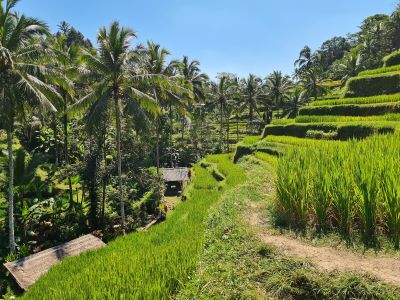
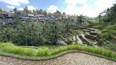
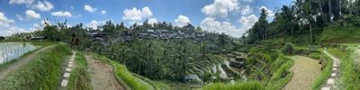
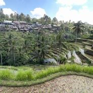
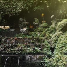
The Tegallalang Rice Terraces form a system of stacked farm fields on Bali's hillsides, held in place by stone walls and connected by narrow pathways. Water channels run between the levels to irrigate the crops and support the traditional farming methods used across this stepped landscape.
Farmers have worked these hillsides for centuries, gradually refining their methods for managing water across the slopes. The techniques for building and maintaining the terraced fields developed slowly through practical experience and local knowledge passed down through generations.
The irrigation system shapes how water flows through different fields and how farmers work together to manage it. This cooperative approach is woven into daily farm life and reflects how the community values shared resources.
The best time to visit is early morning when it is cooler and the paths are less crowded with other visitors. Wear sturdy shoes and bring water, as the pathways become slippery in places and the uphill walks require physical effort.
The fields are farmed entirely by hand without machinery, which makes the work physically demanding and time-consuming for local farmers. Despite easier modern alternatives, farmers maintain these methods because they are tied to the water system and how the community operates.
Location: Tegallalang
Part of: Cultural Landscape of Bali Province: the Subak System as a Manifestation of the Tri Hita Karana Philosophy
Address: Jl. Raya Tagallalang
Opening Hours: Monday-Sunday 07:00-18:00
GPS coordinates: -8.43330,115.28000
Latest update: December 6, 2025 16:00
Walking routes in Bali traverse rice terraces, waterfalls and temple complexes, offering access to the island's varied landscape and cultural sites. The trails range from the sculpted rice paddies of Tegallalang and Jatiluwih to the clifftop setting of Uluwatu Temple and the volcanic slopes of Mount Batur. Visitors will find a network of paths through traditional villages, water gardens and highland areas. The routes include the rolling rice landscapes of Sidemen Valley, forest trails to Sekumpul and Banyumala waterfalls, and the Campuhan Ridge Walk through Ubud. Many paths connect natural features with cultural landmarks such as Gunung Kawi, Tirta Gangga and the rural village of Penglipuran. The coastal walks of Nusa Penida, including Kelingking Beach and Angel's Billabong, provide access to cliffs and sheltered coves along the shoreline.
Ubud Monkey Forest
9.8 km
Tirta Empul Temple
4.3 km
Goa Gajah
10.1 km
Penglipuran Village
8.8 km
Ubud Palace
8.4 km
Gunung Kawi
3.8 km
Istana Tampaksiring
4.1 km
Taman Safari Bali
4.6 km
Pura Taman Saraswati
8.3 km
Pura Dalem Agung Padangtegal
9.8 km
Pura Kehen
8.8 km
Moon of Pejeng
9.1 km
Puri Lukisan Museum
8.3 km
Blanco Renaissance Museum
8.5 km
Neka Art Museum
6.8 km
Agung Rai Museum of Art (ARMA)
10.1 km
Padangtegal
9.1 km
Museum Rudana
10.8 km
Mengening Tampak Siring
3.8 km
Mengening Temple
3.8 km
Agung Rai Museum of Art
10.1 km
Neka Art Museum
7.1 km
Yeh Pulu
11 km
I Made ada Garuda
2.2 km
Campuhan Ridge Walk
8.3 km
Pura Taman Pecampuhan Sala
5.5 km
Tibumana Waterfall
10.1 km
Pura Telaga Waja
4.1 kmVisited this place? Tap the stars to rate it and share your experience / photos with the community! Try now! You can cancel it anytime.
Discover hidden gems everywhere you go!
From secret cafés to breathtaking viewpoints, skip the crowded tourist spots and find places that match your style. Our app makes it easy with voice search, smart filtering, route optimization, and insider tips from travelers worldwide. Download now for the complete mobile experience.
A unique approach to discovering new places❞
— Le Figaro
All the places worth exploring❞
— France Info
A tailor-made excursion in just a few clicks❞
— 20 Minutes