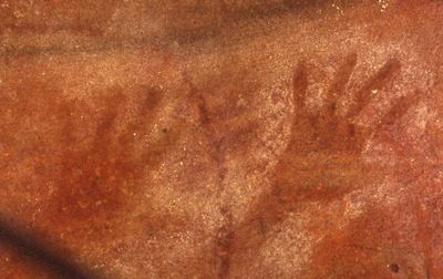
Red Hands Cave, Aboriginal rock art site in Blue Mountains National Park, Australia
Red Hands Cave is a rock shelter featuring hundreds of hand stencils in ochre across its sandstone walls. The natural rock overhang provides protection, and the handprints cover multiple areas of the interior surfaces, created using ancient techniques to apply pigment directly onto the stone.
The site was discovered by a European in 1913, though the handprints themselves date back thousands of years. In the 1930s, local authorities installed protective measures to safeguard the ancient artworks from damage.
The cave walls display hundreds of hand stencils created by Aboriginal artists using ochre and water, serving as personal marks or part of spiritual practices that visitors can see today. These handprints represent a direct connection between ancient people and the rock face, showing how the space held meaning for those who left their marks.
You can reach the site by hiking a longer loop trail or taking a shorter 1-kilometer walk from the parking area. The site sits within the Blue Mountains National Park, and it helps to check locally for current access conditions and trail recommendations before your visit.
The site concentrates hundreds of handprints within a single rock formation, making it one of the most visually striking examples of this type in the region. Many visitors are surprised by the sheer density of preserved prints clustered closely together on the walls.
The community of curious travelers
AroundUs brings together thousands of curated places, local tips, and hidden gems, enriched daily by 60,000 contributors worldwide.