Coleraine Golf Club
Location: Coleraine
Location: Shire of Southern Grampians
GPS coordinates: -37.60311,141.70945
Latest update: December 1, 2025 04:47

Wannon Falls
14.1 km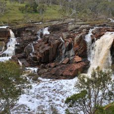
Nigretta Falls
19.9 km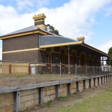
Casterton railway station
27.1 km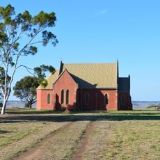
St Peter's church
15.6 km
Peter Francis Points Arboretum
2.1 km
Bald Hill
22.2 km
Stock Selling Ring
26 km
Gringegalgona Homestead
22.3 km
Holy Trinity Anglican Church Complex
1.5 km
Red Brick Barn
15.1 km
Murndal
14.5 km
Mcdougall Hill
19 km
Hamilton Racecourse Grandstand
27.6 km
Gorman's art gallery
26.8 km
Thomas Clark Viewing Area
14.9 km
Peter Francis Points Arboretum
1.9 km
Giant Rock
12.1 km
Wannon Falls
14.2 km
Nigretta Falls
19.8 km
Scenic viewpoint
5.4 km
Points Reserve Arboretum
2 km
Mickle Lookout
26.3 km
Scenic viewpoint
19.9 km
Pitch, monument, skatepark
26.9 km
Ardachy Estate Soldier Settlement Memorial
22.4 km
Bruk Bruk Estate Soldiers Settlement Memorial
22 km
Carapook Soldiers Settlement Memorial
16.5 km
Wando Vale War Memorial
25.5 kmReviews
Visited this place? Tap the stars to rate it and share your experience / photos with the community! Try now! You can cancel it anytime.
Discover hidden gems everywhere you go!
From secret cafés to breathtaking viewpoints, skip the crowded tourist spots and find places that match your style. Our app makes it easy with voice search, smart filtering, route optimization, and insider tips from travelers worldwide. Download now for the complete mobile experience.

A unique approach to discovering new places❞
— Le Figaro
All the places worth exploring❞
— France Info
A tailor-made excursion in just a few clicks❞
— 20 Minutes