Wolfberg Arch
Location: Cederberg Local Municipality
GPS coordinates: -32.44346,19.25388
Latest update: November 19, 2025 09:19
Cederberg
20.2 km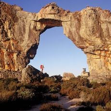
Cederberg Wilderness Area
17.8 km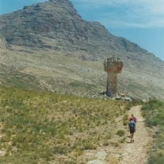
Sneeuberg
11.3 km
Matjiesrivier Nature Reserve
14.7 km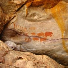
Stadsaal Caves
10.7 km
Middelbergpiek
25.8 km
Middelberg-Noord
20.7 km
Middelberg-Suid
14.1 km
Middelberg-Wes
18.4 km
The Dome
22.4 km
Wolfbergskeure
3.8 km
Old Leopard Trap
11 km
Valley of the Red Gods
4.9 km
Stadsaal Caves
10.8 km
Stadsaal Rock Art
9.6 km
Truitjieskraal
13.4 km
Lot's Wife
5.6 km
Waterfall viewpoint
11.1 km
Bushman Paintings
6.7 km
Rock overhang
12.3 km
Cave entrance, archaeological site
26.1 km
Ruins
12.9 km
Waterfall
12.3 km
Waterfall
11.1 km
Disapool
11.2 km
Waterfall
19.4 km
Warmhoek Falls
24.4 km
Waterfall
27.2 kmReviews
Visited this place? Tap the stars to rate it and share your experience / photos with the community! Try now! You can cancel it anytime.
Discover hidden gems everywhere you go!
From secret cafés to breathtaking viewpoints, skip the crowded tourist spots and find places that match your style. Our app makes it easy with voice search, smart filtering, route optimization, and insider tips from travelers worldwide. Download now for the complete mobile experience.

A unique approach to discovering new places❞
— Le Figaro
All the places worth exploring❞
— France Info
A tailor-made excursion in just a few clicks❞
— 20 Minutes