Lookout Point
Location: Beaufort West Local Municipality
GPS coordinates: -32.28665,22.26675
Latest update: November 20, 2025 09:52
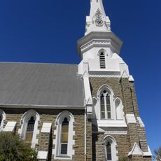
Beaufort West Reformed Church
30.6 km
Beaufort West Dam
31 km
Bobbejaanval
30.3 km
Bobbejaankrans
64.5 km
Rooikrans
59 km
Grootkrans
83.5 km
Papdam
36.1 km
Heuningneskrans
91.9 km
Bobbejaankrans
82 km
Die Grootkrans
79.4 km
Piekniekval
29.6 km
Modderpoort Reservoir
39.3 km
Leeu Gamka Reservoir
43.6 km
Bird Hide
22.7 km
Scenic viewpoint
50.8 km
Riverine Rabbit Thinking Path
90.8 km
Scenic viewpoint
19.9 km
Viewpoint Klippspringer Pass
19.7 km
Scenic viewpoint
18.1 km
Rooivalle Viewpoint
17.9 km
Spookbos
6.1 km
Farm
10.2 km
Ruins
7.3 km
Memorial, commemorative plaque
30.7 km
Memorial, commemorative plaque
30.7 km
Rooivalle
17.8 km
Waterfall
61.3 km
Waterfall
61.3 kmReviews
Visited this place? Tap the stars to rate it and share your experience / photos with the community! Try now! You can cancel it anytime.
Discover hidden gems everywhere you go!
From secret cafés to breathtaking viewpoints, skip the crowded tourist spots and find places that match your style. Our app makes it easy with voice search, smart filtering, route optimization, and insider tips from travelers worldwide. Download now for the complete mobile experience.

A unique approach to discovering new places❞
— Le Figaro
All the places worth exploring❞
— France Info
A tailor-made excursion in just a few clicks❞
— 20 Minutes