River Loop Rd
Location: Thulamela Local Municipality
GPS coordinates: -23.04138,31.39861
Latest update: October 18, 2025 19:21
Mopani Camp
53.5 km
Shingwedzi
8.2 km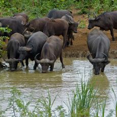
Punda Maria
55 km
Nyawutsi Bird Hide
30.3 km
Limpopo Nationalpark
47.4 km
Day Visitors Area
53.4 km
Shipandani Hide
54.4 km
Kanniedood Dam Hide
10.9 km
Tshanga Waterhole
26.7 km
Scenic viewpoint
49.1 km
Shibavantsengele Viewpoint
44.1 km
Scenic viewpoint
14.8 km
Scenic viewpoint
45.2 km
Scenic viewpoint
8.6 km
Pioneer Dam Bird Hide
54 km
Shipandani Overnight Hide
54.4 km
Dzundzwini Viewpoint
38.5 km
Klopperfontein Dam Viewpoint (Lower)
51.5 km
Mandadzidzi Waterhole
45.8 km
Thulamila Water Viewpoint
53.1 km
Klopperfontein Waterhole Viewpoint
51.3 km
Gora Waterhole
2.4 km
Scenic viewpoint
42 km
Scenic viewpoint
20.1 km
Scenic viewpoint
16.9 km
N'warihlangari
8.2 km
Nkulumbeni
4.7 km
Hippos & Crocs
14.2 kmReviews
Visited this place? Tap the stars to rate it and share your experience / photos with the community! Try now! You can cancel it anytime.
Discover hidden gems everywhere you go!
From secret cafés to breathtaking viewpoints, skip the crowded tourist spots and find places that match your style. Our app makes it easy with voice search, smart filtering, route optimization, and insider tips from travelers worldwide. Download now for the complete mobile experience.

A unique approach to discovering new places❞
— Le Figaro
All the places worth exploring❞
— France Info
A tailor-made excursion in just a few clicks❞
— 20 Minutes