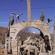
Stone Folk of Ongeluksloot
Location: Camdeboo Local Municipality
GPS coordinates: -31.83864,24.49402
Latest update: October 18, 2025 00:24
The Owl House
6.4 km
Valley of Desolation
47.6 km
Statue d'Andries Pretorius
43.9 km
Graaff-Reinet Museum
46.1 km
Scenic viewpoint
40.4 km
Scenic viewpoint
39 km
Koedoeskloof Waterhole
43.5 km
Kwaggakom Waterhole
49.8 km
Driekoppe Waterhole
52.5 km
Khwalimanzi Hide
41.6 km
Toposcope
47.2 km
Valley of Desolation
47.6 km
Scenic viewpoint
39.8 km
Scenic viewpoint
37.8 km
Steam Train
47.2 km
Kleinhoek Waterhole
47.5 km
Sonnenrust Loop Viewpoint
92.7 km
Scenic viewpoint
47.6 km
Scenic viewpoint
47.4 km
Scenic viewpoint
47.5 km
Dam wall
44.4 km
Scenic viewpoint
47.3 km
Ribbokberg Lookout
45.9 km
Ascon Site office
40.4 km
Scenic viewpoint
47.4 km
Valley of Desolation Yellow Frame
47.2 km
Koedoeskloof
46.3 km
Scenic viewpoint
46.2 kmReviews
Visited this place? Tap the stars to rate it and share your experience / photos with the community! Try now! You can cancel it anytime.
Discover hidden gems everywhere you go!
From secret cafés to breathtaking viewpoints, skip the crowded tourist spots and find places that match your style. Our app makes it easy with voice search, smart filtering, route optimization, and insider tips from travelers worldwide. Download now for the complete mobile experience.

A unique approach to discovering new places❞
— Le Figaro
All the places worth exploring❞
— France Info
A tailor-made excursion in just a few clicks❞
— 20 Minutes