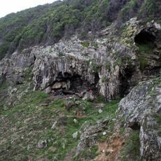
Skulphoop Shell Midden
Location: Hessequa Local Municipality
GPS coordinates: -34.38654,21.42536
Latest update: November 21, 2025 01:29
Blombos Cave
19.2 km
Stilbaai Marine Protected Area
875 m
Bridges over the Gourits River
37.6 km
Ystervarkpuntvuurtoring
27.8 km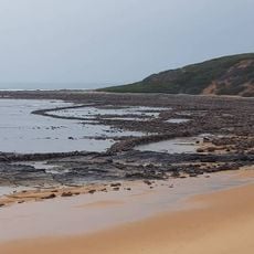
Stilbaai Tidal Fish Traps
1.7 km
Grootjongensfonteinstrand
9.9 km
Rooikrans
10.9 km
Bloukrans
19.3 km
Shelly Beach
713 m
Kanonstrand
44.5 km
Blombosstrand
20.3 km
Jongensgat
5.1 km
Geelkrans
6.3 km
Reisiesbaan
23.8 km
Langekloof Peak
46.9 km
Ramskraal
24 km
Maalhoek
27.5 km
Kareekop
49.1 km
Cross
45.2 km
Riversdale Golfcourse
33.3 km
Oystercatcher Hiking Trail
46.8 km
Gouritsmond Beach
42.2 km
Scenic viewpoint
48.7 km
Scenic viewpoint
48.6 km
Scenic viewpoint
37.6 km
Uitkyk punt
675 m
Scenic viewpoint
48.4 km
Stillbay petrified forest
180 mReviews
Visited this place? Tap the stars to rate it and share your experience / photos with the community! Try now! You can cancel it anytime.
Discover hidden gems everywhere you go!
From secret cafés to breathtaking viewpoints, skip the crowded tourist spots and find places that match your style. Our app makes it easy with voice search, smart filtering, route optimization, and insider tips from travelers worldwide. Download now for the complete mobile experience.

A unique approach to discovering new places❞
— Le Figaro
All the places worth exploring❞
— France Info
A tailor-made excursion in just a few clicks❞
— 20 Minutes