Sanke Wetland Park
Location: 夏河县 བསང་ཆུ་རྫོང་།
GPS coordinates: 35.13962,102.46117
Latest update: October 15, 2025 22:05
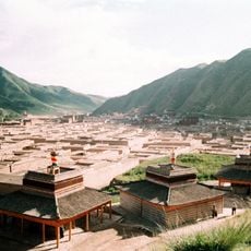
Labrang Monastery
7.3 km
Baishiya Karst Cave
35.8 km
Tso Monastery
43.5 km
Terlong Gompa
31.3 km
Arejiadehe
25.4 km
Dejiayibaigan
17.6 km
Monument
7 km
Scenic viewpoint
6.7 km
Scenic viewpoint
6.9 km
Ruins
8.4 km
Monument
8.6 km
Scenic viewpoint
17 km
Beginning of the outer Kora
6.7 km
Scenic viewpoint
6.7 km
Ruins
29.2 km
甘加秘境
29.4 km
Scenic viewpoint
31.1 km
Hermitage ruins
7 km
Ruins, tower
35.4 km
Monument
6.6 km
Monument
38.9 km
Ruins
42.1 km
阿木去乎观景台
42.3 km
Scenic viewpoint
43 km
Scenic viewpoint
43.3 km
Wetlands
303 m
黑力宁巴观景台
43.6 km
辩经场
43.6 kmReviews
Visited this place? Tap the stars to rate it and share your experience / photos with the community! Try now! You can cancel it anytime.
Discover hidden gems everywhere you go!
From secret cafés to breathtaking viewpoints, skip the crowded tourist spots and find places that match your style. Our app makes it easy with voice search, smart filtering, route optimization, and insider tips from travelers worldwide. Download now for the complete mobile experience.

A unique approach to discovering new places❞
— Le Figaro
All the places worth exploring❞
— France Info
A tailor-made excursion in just a few clicks❞
— 20 Minutes