Canyons of Munara
Location: Кеген ауданы
Address: Алматинская область, Енбекшиказахский район
GPS coordinates: 43.35640,79.10414
Latest update: November 12, 2025 03:48
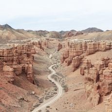
Charyn Canyon
1.3 km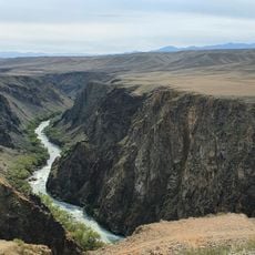
Charyn National Park
2.9 km
Natural Monument "Charyn ash forest"
33.3 km
Чёрный Чарынский каньон
3.4 km
Волчьи ворота
30.9 km
Развилка к ЛЭП
5.5 km
Вид сверху на каньон
2.7 km
Площадка у реки
2 km
Лунный каньон, смотровая площадка
12.6 km
Black canyon
20.7 km
Scenic viewpoint
20.3 km
Вид на каньон Темерлик
3.9 km
Scenic viewpoint
5.6 km
Viewpoint shelter
3.4 km
Yellow canyon
1.6 km
Вид на обе долины
32.2 km
Clay canyon
14.1 km
Лунный каньон
14.4 km
Scenic viewpoint
3.3 km
Scenic viewpoint
5.3 km
Scenic viewpoint
5.5 km
Scenic viewpoint
12 km
Scenic viewpoint
20.6 km
Scenic viewpoint
5.1 km
Kegen
14.5 km
Ruins
30.8 km
Qalybek Batyr
25.8 km
Ruins
30.8 kmReviews
Visited this place? Tap the stars to rate it and share your experience / photos with the community! Try now! You can cancel it anytime.
Discover hidden gems everywhere you go!
From secret cafés to breathtaking viewpoints, skip the crowded tourist spots and find places that match your style. Our app makes it easy with voice search, smart filtering, route optimization, and insider tips from travelers worldwide. Download now for the complete mobile experience.

A unique approach to discovering new places❞
— Le Figaro
All the places worth exploring❞
— France Info
A tailor-made excursion in just a few clicks❞
— 20 Minutes