Хобой
Location: Хужирское сельское поселение
GPS coordinates: 53.40541,107.78036
Latest update: November 3, 2025 02:57
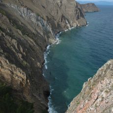
Lake Baikal
18.8 km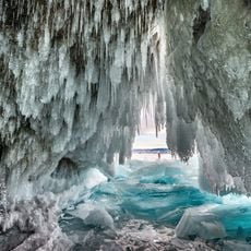
Ice cave on Olkhon island
26.9 km
Cape Right Shuntae
15.4 km
Cape Sagan-Hushun (Three Brothers)
3.8 km
Cape Left Shuntae
1.7 km
Modoto rock
29.5 km
Nyurganskaya bay
17.3 km
Cape Budun
23.7 km
Cape Kharaldai
29.2 km
Cape Kharantsy
30.8 km
Abandoned Village
8 km
Хранитель Байкала
8.1 km
The deepest place of Lake Baikal
26.7 km
Будыская губа
30.9 km
Гора "Жима"
18.9 km
Старый причал
18.6 km
Хижина Буругер
19.8 km
Страж Ольхона
22.4 km
Идеальный лёд
29.2 km
Мыс Улан Ирги. Пещера Сквозная
6 km
Дерево-Паук.
22.4 km
Металическое древо «Хранитель Байкала»
8 km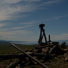
Scenic viewpoint
1.4 km
Scenic viewpoint
3.7 km
Scenic viewpoint
842 m
Scenic viewpoint
8.9 km
Вид с мыса Хобой
944 m
Scenic viewpoint
445 mReviews
Visited this place? Tap the stars to rate it and share your experience / photos with the community! Try now! You can cancel it anytime.
Discover hidden gems everywhere you go!
From secret cafés to breathtaking viewpoints, skip the crowded tourist spots and find places that match your style. Our app makes it easy with voice search, smart filtering, route optimization, and insider tips from travelers worldwide. Download now for the complete mobile experience.

A unique approach to discovering new places❞
— Le Figaro
All the places worth exploring❞
— France Info
A tailor-made excursion in just a few clicks❞
— 20 Minutes