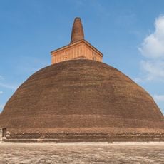
Kiribath Wahera
Location: Anuradhapura District
GPS coordinates: 8.39956,80.40046
Latest update: October 15, 2025 22:11
Abhayagiri vihāra
3.2 km
Lankarama
4.1 km
Mahamevnāwa Park in Anuradhapura
4.3 km
Puliyankulama Wewa
4.2 km
Main Refectory
3.6 km
Mahayana Stupa
3.7 km
Pankuliya Ashokaramaya
1.8 km
Dighapashana cave
3.3 km
Image house
3.4 km
Moonstone II
3.5 km
Assembly Hall
3.5 km
Second Samadhi Buddha Statue
3.5 km
Refectory
3.5 km
Wijayarama Archaeological Site
914 m
Prasada Stupa
3.6 km
Ruins Main Residential Complex
3.6 km
Relic Shrine
3.7 km
Kapara Mulaya
3 km
Abhayagiriya Museum
3.7 km
Cave shelter
3.8 km
Ramakele Ruins
4.1 km
Ancient Stone Bridge
605 m
Gal Palama
604 m
Ancient Stone Bridge
602 m
Vaulted Vihara (Gedige) Image House of Anuradhapura
4.4 km
Citadel
4.5 km
Mahapali Alms-Hall
4.5 km
Ruins
4.5 kmReviews
Visited this place? Tap the stars to rate it and share your experience / photos with the community! Try now! You can cancel it anytime.
Discover hidden gems everywhere you go!
From secret cafés to breathtaking viewpoints, skip the crowded tourist spots and find places that match your style. Our app makes it easy with voice search, smart filtering, route optimization, and insider tips from travelers worldwide. Download now for the complete mobile experience.

A unique approach to discovering new places❞
— Le Figaro
All the places worth exploring❞
— France Info
A tailor-made excursion in just a few clicks❞
— 20 Minutes