Ban Tong Luang
Location: จังหวัดเชียงใหม่
GPS coordinates: 18.89574,98.88084
Latest update: November 15, 2025 01:00
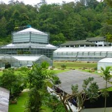
Queen Sirikit Botanic Garden
2.3 km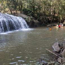
Mae Sa Waterfall (Nam tok Mae Sa)
2 km
Jiang Lha / Ne'-Na Contemporary Art Space; Annex site.
2.9 km
Cascade 7 Tat Phanarom
1.8 km
Thai Elephant Care Center
860 m
Mae Rim Snake Farm
3.6 km
Siam insect Zoo
3.8 km
Strawberry farm
1.6 km
Mae Sa waterfall
2.2 km
Banana Avenue
2 km
White flower Collection
2.1 km
Palm garden
2.3 km
Queen Sirikit Botanic Garden
2.2 km
Canopy Walks
2 km
Mae Sa Waterfall
2.1 km
Maesa Elephant Camp
723 m
Cascade 10 Lan Thay
1.4 km
Scenic viewpoint
1.6 km
Scenic viewpoint
2.1 km
End of walking trail
1.4 km
Scenic viewpoint
2.8 km
Cascade 9 Wat Hang
1.5 km
Rest zone - 2 tables with branches
1.7 km
Cascade 8 Pha Ngoeb
1.8 km
Work of art
3.7 km
Cascade 6 Tat Muei
1.9 km
Scenic viewpoint
2.7 km
Waterfall
1.2 kmReviews
Visited this place? Tap the stars to rate it and share your experience / photos with the community! Try now! You can cancel it anytime.
Discover hidden gems everywhere you go!
From secret cafés to breathtaking viewpoints, skip the crowded tourist spots and find places that match your style. Our app makes it easy with voice search, smart filtering, route optimization, and insider tips from travelers worldwide. Download now for the complete mobile experience.

A unique approach to discovering new places❞
— Le Figaro
All the places worth exploring❞
— France Info
A tailor-made excursion in just a few clicks❞
— 20 Minutes