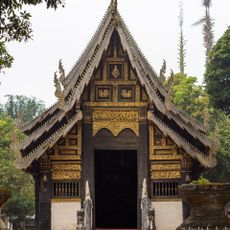
บ่อน้ำศักดิ์สิทธิ์
Location: จังหวัดเชียงใหม่
GPS coordinates: 18.51333,98.35128
Latest update: November 15, 2025 04:31
Wat Pa Daet
4.7 km
Wat Phut En
76 m
Wat Yang Luang
4.7 km
Wat Ban Chiang
850 m
Wat Kong Kan
3.9 km
Wat Kong Khaek
9.8 km
MonSonkeang Camping view ม่อนสันเกี๋ยง
6.4 km
Nam Tok Huai Sai Lueang
11.2 km
Nam Tok Mae Pan
10.6 km
นาขั้นบันไดป่าปงเปียง
10.4 km
Mae Pan Waterfall
11.2 km
Suspension bridge
1.8 km
Wooden suspension foot bridge
3.8 km
Wooden suspension foot bridge
3.7 km
ขัวโต๋งเต๋ง
3.7 km
นาขั้นบันไดป่าปงเปียง
10.1 km
มนต์เมืองแจ่ม
6.6 km
ดอยม่อนหมาก
5.8 km
Traditional Cotton Woven Village
2.7 km
Sunrise viewpoint
4.4 km
Viewpoint 360
4.9 km
Scenic viewpoint
5.8 km
Scenic viewpoint
9.8 km
Scenic viewpoint
9.3 km
Scenic viewpoint
9.4 km
Waterfall
10.8 km
Pha Sam Lam waterfall
10.8 km
อ่างเก็บน้ำแม่ออกฮู
5.1 kmReviews
Visited this place? Tap the stars to rate it and share your experience / photos with the community! Try now! You can cancel it anytime.
Discover hidden gems everywhere you go!
From secret cafés to breathtaking viewpoints, skip the crowded tourist spots and find places that match your style. Our app makes it easy with voice search, smart filtering, route optimization, and insider tips from travelers worldwide. Download now for the complete mobile experience.

A unique approach to discovering new places❞
— Le Figaro
All the places worth exploring❞
— France Info
A tailor-made excursion in just a few clicks❞
— 20 Minutes