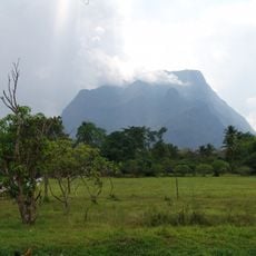
Swimming spot at river
Location: จังหวัดเชียงใหม่
GPS coordinates: 19.32284,98.75625
Latest update: November 14, 2025 17:19
Cave of the Monk
11.3 km
Nam Tok Huai Nam Dang
14.3 km
Pong Duet Geyser
11.3 km
Elephant Adventure Sanctuary
12.6 km
High Forest Development Project
7.8 km
Scenic viewpoint
14.5 km
Scenic viewpoint
6.8 km
Kong Gnam Viewpoint
14.1 km
Point of view and drink
14 km
Viewpoint
14.1 km
Scenic viewpoint
7.2 km
จุดชมวิวโค้งงาม
14.1 km
Scenic viewpoint
10.9 km
Scenic viewpoint
8.1 km
Scenic viewpoint
13.3 km
บ้านแสงตะวัน @ เชียงดาว
13.7 km
Scenic viewpoint
12.3 km
Scenic viewpoint
6.1 km
Scenic viewpoint
10.5 km
Sagee Waterfall
14.2 km
น้ำตกไทรลอดบ่วง
12.3 km
Waterfall
11.3 km
Waterfall
11.4 km
Waterfall
10.8 km
นำต้กตาดหมอก
11.1 km
Waterfall
10.9 km
Waterfall
8.1 km
Waterfall
10.1 kmReviews
Visited this place? Tap the stars to rate it and share your experience / photos with the community! Try now! You can cancel it anytime.
Discover hidden gems everywhere you go!
From secret cafés to breathtaking viewpoints, skip the crowded tourist spots and find places that match your style. Our app makes it easy with voice search, smart filtering, route optimization, and insider tips from travelers worldwide. Download now for the complete mobile experience.

A unique approach to discovering new places❞
— Le Figaro
All the places worth exploring❞
— France Info
A tailor-made excursion in just a few clicks❞
— 20 Minutes