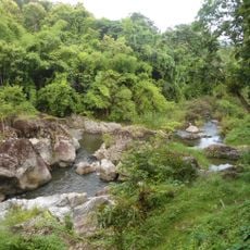
Nam Tok Kaeng Ko Yai
Location: จังหวัดกำแพงเพชร
GPS coordinates: 15.91924,99.36875
Latest update: November 16, 2025 15:27
Mae Wong National Park
19.7 km
Khlong Lan National Park
32.8 km
Khlong Lan Waterfall
25.5 km
Nam Tok Khlong Nam Lai
32.9 km
Nam Tok Khlong Lan
25.5 km
Wat Khlong Phrao
34.4 km
Buddha
19.3 km
Scenic viewpoint
25.4 km
Kaeng Ko Yai Nakhon Sawan
212 m
Kaeng Pha Khoi Nang
20.3 km
Khlong Lan Flora Park
25.6 km
Nam Tok Mae Riwa
24.9 km
Gaeng Lan Nok Yung
4.6 km
Buddha
17 km
Field stone rampart
33.8 km
Buddha
19.4 km
พระพูดรูป
28.3 km
อช.แม่วงก์ โมโกจู
16 km
Scenic viewpoint
25.2 km
Scenic viewpoint
25.3 km
Khlong Lan Waterfall
25.5 km
น้ำตกคลองน้ำไหล
32.6 km
เขาโมโกจู หินเรือใบ
29.2 km
จุดชมวิวกิ่วกระทิง
31.2 km
ภูสวรรค์ ช่องเย็น
34.7 km
จุดชมวิวขุนน้ำเย็น
32.7 km
โมโกจูน้อย
31.7 km
น้ำตกคลองน้ำไหล
32.6 kmReviews
Visited this place? Tap the stars to rate it and share your experience / photos with the community! Try now! You can cancel it anytime.
Discover hidden gems everywhere you go!
From secret cafés to breathtaking viewpoints, skip the crowded tourist spots and find places that match your style. Our app makes it easy with voice search, smart filtering, route optimization, and insider tips from travelers worldwide. Download now for the complete mobile experience.

A unique approach to discovering new places❞
— Le Figaro
All the places worth exploring❞
— France Info
A tailor-made excursion in just a few clicks❞
— 20 Minutes