Rice Fields
Location: Thị xã Hương Thuỷ
GPS coordinates: 16.43783,107.64756
Latest update: November 17, 2025 09:38
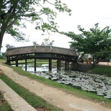
Thanh Toan covered bridge
3.3 km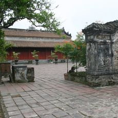
Tomb of Dục Đức
6 km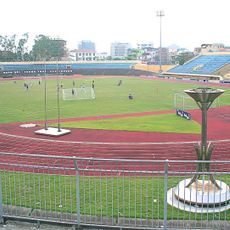
Independence Stadium
6.3 km
Long An Palace
6 km
Nightmarket
5.8 km
Thanh Thuy Chanh Communal House
2.6 km
Thanh Thuy Clanh Village
2.7 km
Temple of Literature
2.9 km
Tran Family's Ancestral House
2.6 km
Lady Buddha
6.3 km
Shrine and Graveyard
3.9 km
Van Duong Bridge
5.9 km
Chau Son Bridge
2.3 km
Rice Fields
6.1 km
Market - Local Producers
3.2 km
Tumba del Emperador Duc Duc
6 km
Large Lake
3.1 km
Pont couvert de Thanh Toan
3.1 km
Chin Ham Historical Relics and Bunkers
5.1 km
Cây cảnh Thảo Nguyên
5.3 km
Jesus Christ
5.9 km
Work of art, sculpture
5.7 km
Sculpture, Work of art
5.7 km
Street
2.2 km
Great Sunset Viewpoint
5.7 km
Tượng đài vua Quang Trung
6 km
Rain shelter because it always rain in Huế
6.2 km
Lăng Dục Đức
6 kmReviews
Visited this place? Tap the stars to rate it and share your experience / photos with the community! Try now! You can cancel it anytime.
Discover hidden gems everywhere you go!
From secret cafés to breathtaking viewpoints, skip the crowded tourist spots and find places that match your style. Our app makes it easy with voice search, smart filtering, route optimization, and insider tips from travelers worldwide. Download now for the complete mobile experience.

A unique approach to discovering new places❞
— Le Figaro
All the places worth exploring❞
— France Info
A tailor-made excursion in just a few clicks❞
— 20 Minutes