Quang Ngai Stone Wall
Location: Huyện Nghĩa Hành
GPS coordinates: 15.06456,108.70134
Latest update: November 16, 2025 11:32
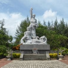
Sơn Mỹ Memorial
23.7 km
Tra Khuc 1 Bridge
13.4 km
Tra Khuc 2 Bridge
13.8 km
Co Luy Bridge
21.6 km
Thach Bich Bridge
12.1 km
Quang Ngai Stone Wall
25.9 km
An Hai Beach
32.4 km
Great Beach for Rock Pooling
30.1 km
NTT house
13.2 km
Công ty TNHH NLG THƯỢNG HẢI
28.7 km
Thạch kỳ điếu tẩu
28.4 km
Work of art
26.5 km
View Point
28.4 km
Great Headland Viewpoint
28.4 km
Tra Khuc River Viewpoint and Ferry Crossing
8.5 km
Tra Khuc River and Dam Viewpoint
11.1 km
Son Tay Viewpoint
31 km
Valley Viewpoint
35.3 km
Hillside Viewpoint of Tra Khuc River
25.9 km
Dung Quat Shipyard (Drydock)
37.4 km
Ruins
18.3 km
Ruins
18.3 km
Monument
32.5 km
Tổ quốc Ghi công
37.8 km
Tổ quốc Ghi công
29.3 km
Tổ quốc Ghi công
24.3 km
Trang Minh Long Waterfall
18.2 km
Thác Savannah
5.8 kmReviews
Visited this place? Tap the stars to rate it and share your experience / photos with the community! Try now! You can cancel it anytime.
Discover hidden gems everywhere you go!
From secret cafés to breathtaking viewpoints, skip the crowded tourist spots and find places that match your style. Our app makes it easy with voice search, smart filtering, route optimization, and insider tips from travelers worldwide. Download now for the complete mobile experience.

A unique approach to discovering new places❞
— Le Figaro
All the places worth exploring❞
— France Info
A tailor-made excursion in just a few clicks❞
— 20 Minutes