Probable site of old hut
Location: Jeogla
Location: Armidale Regional Council
GPS coordinates: -30.78836,152.14823
Latest update: November 21, 2025 12:58
Oxley Wild Rivers National Park
17.8 km
Carrai National Park
14 km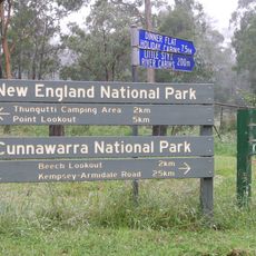
Cunnawarra National Park
27.9 km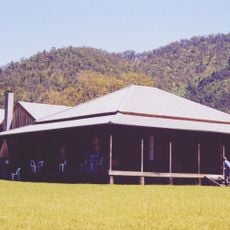
Kunderang East Pastoral Station
12.9 km
Scenic viewpoint
21.2 km
Chandler River Lookout
24.3 km
Old cattle yards
25.8 km
Scenic viewpoint
12.3 km
Scenic viewpoint
16.4 km
Scenic viewpoint
10.8 km
Scenic viewpoint
12.4 km
Budds Mare Lookout
27.5 km
Scenic viewpoint
21.9 km
Scenic viewpoint
4.3 km
Aboriginal bark-stripped tree
23.9 km
Aboriginal Coolamon tree
24.2 km
Eely Creek Fire Lookout
24.7 km
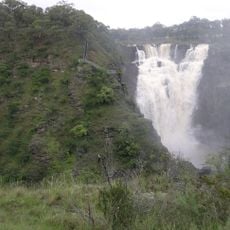
Falls Lookout
13.6 km
Raspberry Fire Lookout
12.2 km
Marys View
6.8 km
Scenic viewpoint
6.5 km
Remains of hearth
9.3 km
Cattle yards (1890's)
24.3 km
Old water well
19 km
Possible site of old hut
19 km
Old cattle yards (corner post)
17 km
Old cattle yards (corner post)
16.8 km
Oaky Falls
24.8 kmReviews
Visited this place? Tap the stars to rate it and share your experience / photos with the community! Try now! You can cancel it anytime.
Discover hidden gems everywhere you go!
From secret cafés to breathtaking viewpoints, skip the crowded tourist spots and find places that match your style. Our app makes it easy with voice search, smart filtering, route optimization, and insider tips from travelers worldwide. Download now for the complete mobile experience.

A unique approach to discovering new places❞
— Le Figaro
All the places worth exploring❞
— France Info
A tailor-made excursion in just a few clicks❞
— 20 Minutes