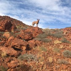
Maralinga Lands Western Boundary
Location: Maralinga Tjarutja
GPS coordinates: -28.56372,130.99834
Latest update: November 22, 2025 09:47

Mount Woodroffe
260.7 km
Tallaringa Conservation Park
238 km
Mount Kintore
228.7 km
Mount Wooltarlinna
203.2 km
Yurrauwe Pans
66.4 km
Voakes Hill
41.7 km
Mount Lindsay
203.3 km
Coffin Hill
126.4 km
Unnamed Biosphere Reserve
117.2 km
Mount Tietkens
219 km
Purndu Saltpan
150.9 km
Great Victoria Desert Nature Reserve
191.5 km
Observatory Hill
113.5 km
Woomera Prohibited Area Western Boundary
49.4 km
Antler Round 3/Taranaki
159 km
Atomic Testing Ground Zero Obelisk - Totem 1
135 km
Atomic Testing Ground Zero Obelisk - Totem 2
135.7 km
Antler Round 2/Biak
159.7 km
Buffalo R2/Marcoo
158.8 km
Buffalo R3/Kite
160.4 km
Maralinga Lands Eastern Boundary
94.2 km
Buffalo R4/Breakaway
159.3 km
Antler Round 1/Tadje
160.5 km
Gona - Proposed Bomb Detonation Site
161.9 km
Tufi - Bomb Detonation Site
162.2 km
Daisy Bates Memorial
226 km
Linking of the Rails Monument
225.5 km
Linking of the Rails Monument
225.4 kmReviews
Visited this place? Tap the stars to rate it and share your experience / photos with the community! Try now! You can cancel it anytime.
Discover hidden gems everywhere you go!
From secret cafés to breathtaking viewpoints, skip the crowded tourist spots and find places that match your style. Our app makes it easy with voice search, smart filtering, route optimization, and insider tips from travelers worldwide. Download now for the complete mobile experience.

A unique approach to discovering new places❞
— Le Figaro
All the places worth exploring❞
— France Info
A tailor-made excursion in just a few clicks❞
— 20 Minutes