Boat Ramp
Location: Katherine
Location: Town of Katherine
GPS coordinates: -14.46170,132.26077
Latest update: October 15, 2025 22:12
Cutta Cutta Caves Nature Park
26 km
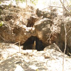
Kintore Caves Conservation Reserve
11.8 km
The Katherine Museum
2.4 km
Dakota Park
1.4 km
Jukes Park
1.8 km
Double Hill
16.9 km
Callistemon Park
2.2 km
Ryan Park
199 m
Maluka Park
2 km
Roney Park
3.7 km
Donkey Camp Weir
8.3 km
Memorial
3 km
Sabu Sing Statue
903 m
Katherine Golf Club
1.1 km
Scenic viewpoint
27.1 km
Knotts Crossing
3.3 km
Baruwei Lookout
24.5 km
Waterfall
25.7 km
Southern Rockhole
25.9 km
Pat's Lookout
25.9 km
Top Didj
5.8 km
Jeddas Rock
26.3 km
Aboriginal
26.4 km
Butterfly Gorge
26.5 km
Scenic viewpoint
24.4 km
Work of art
28.2 km
Lilly Pond Falls
28.2 km
Biddlecombe Cascades
29.9 kmReviews
Visited this place? Tap the stars to rate it and share your experience / photos with the community! Try now! You can cancel it anytime.
Discover hidden gems everywhere you go!
From secret cafés to breathtaking viewpoints, skip the crowded tourist spots and find places that match your style. Our app makes it easy with voice search, smart filtering, route optimization, and insider tips from travelers worldwide. Download now for the complete mobile experience.

A unique approach to discovering new places❞
— Le Figaro
All the places worth exploring❞
— France Info
A tailor-made excursion in just a few clicks❞
— 20 Minutes