Marrangaroo Interchange
Location: Marrangaroo
Location: Lithgow City Council
GPS coordinates: -33.42635,150.10361
Latest update: November 17, 2025 08:22
Lithgow State Mine Heritage Park & Railway
7.2 km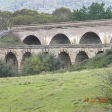
Bowenfels rail viaducts
5.6 km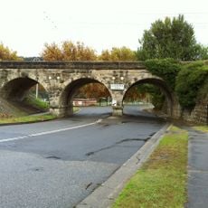
Lithgow Underbridge
7.6 km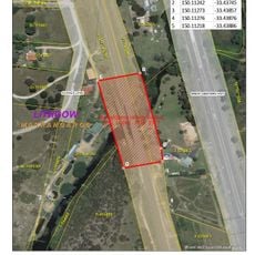
Marrangaroo railway viaduct
1.5 km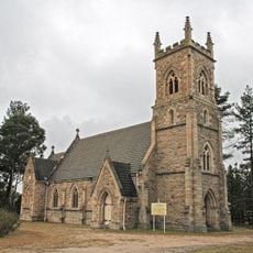
St John the Evangelist Church, Wallerawang
3.7 km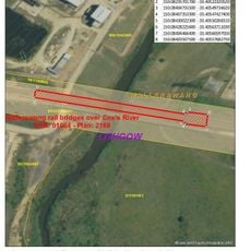
Coxs River railway bridges, Wallerangang
3 km
Marrangaroo National Park
4.7 km
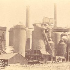
Lithgow Small Arms Factory Museum
7.7 km
Wallerawang Reservoir
2.4 km
Lost City viewpoint
6.5 km
South Lost City Lookout
6.4 km
Jannei Goat Dairy - artisan cheese
6.8 km
Gang Gang Gallery
7.7 km
Lithgow Visitor Information Center
6.5 km
Lithgow Golf Club
3.2 km
Lookout
5.6 km
Lost City
5.6 km
Lost City
5.9 km
Lost City Theme Park (proposed)
6.4 km
Scenic viewpoint
7.5 km
Dobbs Drift Lookout
7.3 km
Miners Memorial
6.7 km
Ruins
7.2 km
Old water pumping station
6.4 km
Ruins
7.1 km
Memorial stone, memorial
3.7 km
War memorial, memorial
3.9 km
Father O'Farrell
3.5 kmReviews
Visited this place? Tap the stars to rate it and share your experience / photos with the community! Try now! You can cancel it anytime.
Discover hidden gems everywhere you go!
From secret cafés to breathtaking viewpoints, skip the crowded tourist spots and find places that match your style. Our app makes it easy with voice search, smart filtering, route optimization, and insider tips from travelers worldwide. Download now for the complete mobile experience.

A unique approach to discovering new places❞
— Le Figaro
All the places worth exploring❞
— France Info
A tailor-made excursion in just a few clicks❞
— 20 Minutes