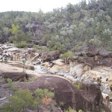
Wallangra Dry Fossicking Area
Location: Wallangra
Location: Inverell Shire Council
Operator: Inverell Shire Council
GPS coordinates: -29.25255,150.89606
Latest update: November 13, 2025 08:17
Kwiambal National Park
18.3 km
Warialda Pioneer Cemetery
45.2 km
Crooked Creek National Park
35.5 km
Bonshaw Weir
47.1 km
Burral Yurrul National Park
19.7 km
Bullala National Park
54 km
Cranky Rocks
41.7 km
Scenic viewpoint
13 km
Yetman Store Mural
40.4 km
Koloona School Site
44.4 km
R2B2 Wild Honey
44.7 km
Texas Cultural Centre
51.6 km
Coffee & Art Gallery
44.8 km
Scenic viewpoint
38.6 km
The Dungeon
15.5 km
Pindari Lookout
38.2 km
Nancy Coulton Lookout Rest Area
53.9 km
Warialda Swimsuit and Bra Tree
42.3 km
Severn River Falls
15.1 km
Commemorative plaque, memorial
41.9 km
ANZAC Memorial
14.1 km
Memorial
45.3 km
Monument
51.1 km
Tomb, cinerarium
46.7 km
Memorial, war memorial
45.2 km
Macintyre Falls
13 km
Eight Mile Falls
44.9 km
Severn River Falls
15.4 kmReviews
Visited this place? Tap the stars to rate it and share your experience / photos with the community! Try now! You can cancel it anytime.
Discover hidden gems everywhere you go!
From secret cafés to breathtaking viewpoints, skip the crowded tourist spots and find places that match your style. Our app makes it easy with voice search, smart filtering, route optimization, and insider tips from travelers worldwide. Download now for the complete mobile experience.

A unique approach to discovering new places❞
— Le Figaro
All the places worth exploring❞
— France Info
A tailor-made excursion in just a few clicks❞
— 20 Minutes