Old Logging Cart
Location: Tregony
Location: Southern Downs Regional
Opening Hours: 24/7
GPS coordinates: -28.07440,152.41556
Latest update: November 22, 2025 01:30
Moogerah Peaks National Park
14 km
Spicers Gap Road
917 m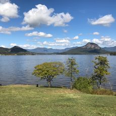
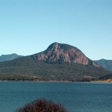
Lake Moogerah
11.9 km
Goomburra State Forest
3.6 km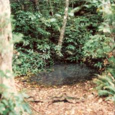
Spicers Gap State Forest
1.9 km
Bare Rock
6.1 km
Scenic viewpoint
4.5 km
Poplar Flat camping area Main Range NP
12.7 km
Poplar Flat camping area Main Range NP
12.8 km
Tardis
5.9 km
Scenic viewpoint
8.6 km
Baby View
8.5 km
Slab Rock
8.9 km
Scenic viewpoint
3.4 km
The Steamers Trailhead Carpark
13.7 km
Mount Cordeaux Lookout
4 km
Manna Gum camping area Main Range NP
12.4 km
Scenic viewpoint
4 km
Auracaria Falls
12.7 km
Sylvesters lookout
11.2 km
Governors Chair
1.4 km
Mount Castle Lookout
12.4 km
Scenic viewpoint
5.7 km
Memorial
3.4 km
Moss Well
831 m
Cascade Falls
10.4 km
Waterfall
12.7 km
Waterfall
12.7 kmReviews
Visited this place? Tap the stars to rate it and share your experience / photos with the community! Try now! You can cancel it anytime.
Discover hidden gems everywhere you go!
From secret cafés to breathtaking viewpoints, skip the crowded tourist spots and find places that match your style. Our app makes it easy with voice search, smart filtering, route optimization, and insider tips from travelers worldwide. Download now for the complete mobile experience.

A unique approach to discovering new places❞
— Le Figaro
All the places worth exploring❞
— France Info
A tailor-made excursion in just a few clicks❞
— 20 Minutes