Canoe Ramp
Location: Middle Harbour
Location: Sydney
GPS coordinates: -33.76759,151.19983
Latest update: October 11, 2024 01:47
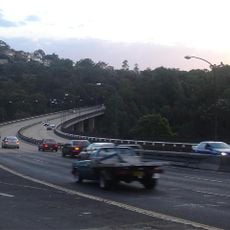
Roseville Bridge
725 m
Davidson Park State Recreation Area
2.5 km
Little Digger Park
1.6 km
Willis Park
1.6 km
Roseville Park
1.4 km
Beauchamp Park
2.1 km
Little Falls
870 m
Waterfall
1.7 km
Memorial, commemorative plaque
980 m
Scenic viewpoint
1.2 km
Babbage Falls
762 m
Waterfall
1.5 km
Memorial, war memorial
1.5 km
Archaeological site
520 m
Headland Lookout
1.6 km
Scenic viewpoint
1.6 km
Waterfall
467 m
Roseville Golf Course
930 m
Scenic viewpoint
1.7 km
Scenic viewpoint
1.7 km
The Amphitheatre
1.8 km
Scenic viewpoint
1.9 km
Castle Cove Golf Club
2 km
Scenic viewpoint
349 m
Turner Lookout
2.2 km
Scenic viewpoint
2.3 km
Waterfall
2.4 km
Waterfall
313 mReviews
Visited this place? Tap the stars to rate it and share your experience / photos with the community! Try now! You can cancel it anytime.
Discover hidden gems everywhere you go!
From secret cafés to breathtaking viewpoints, skip the crowded tourist spots and find places that match your style. Our app makes it easy with voice search, smart filtering, route optimization, and insider tips from travelers worldwide. Download now for the complete mobile experience.

A unique approach to discovering new places❞
— Le Figaro
All the places worth exploring❞
— France Info
A tailor-made excursion in just a few clicks❞
— 20 Minutes