Historic Talbot
Location: Talbot
Location: Shire of Central Goldfields
GPS coordinates: -37.17143,143.70182
Latest update: November 22, 2025 16:13

Paddys Ranges State Park
6.6 km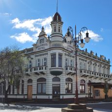
Bull and Mouth Hotel
14.2 km
Belltower, Maryborough Fire Station
14.3 km
Princes Park
14.7 km
Maryborough Town Hall
14.3 km
Maryborough Municipal Olympic Swimming Complex
14.5 km
Maryborough Court House
14.2 km
Maryborough Post Office
14.3 km
Phillips Gardens
14 km
Stony Creek School Reserve
6.8 km
Carisbrook Reservoir
13.3 km
Hamlin Pipe Organ
15.4 km
Former Maryborough High School
14.3 km
Prince's Park
14.8 km
Former Maryborough Technical School No. 7225
13.9 km
Cab Building and House
14.4 km
Former Police Residence and Lock-Up
79 m
Former Primary School No.2828
13.7 km
Talbot Golf Club
2.8 km
Amherst Winery
3 km
Clunes Golf Course
13.5 km
War Mamorial/Lookout
13.9 km
Clunes (Gold Town)
15.2 km
Old Maryborough Gaol Entrance
14.4 km
Monument
15.1 km
First World War Nurses War Memorial
13.5 km
First World War Soldiers Memorial
13.5 km
Memorial
14.3 kmReviews
Visited this place? Tap the stars to rate it and share your experience / photos with the community! Try now! You can cancel it anytime.
Discover hidden gems everywhere you go!
From secret cafés to breathtaking viewpoints, skip the crowded tourist spots and find places that match your style. Our app makes it easy with voice search, smart filtering, route optimization, and insider tips from travelers worldwide. Download now for the complete mobile experience.

A unique approach to discovering new places❞
— Le Figaro
All the places worth exploring❞
— France Info
A tailor-made excursion in just a few clicks❞
— 20 Minutes