Aire de battage
Location: Saint-Maurice-de-Ventalon
Location: Pont de Montvert - Sud Mont Lozère
GPS coordinates: 44.35366,3.83737
Latest update: November 11, 2025 15:38
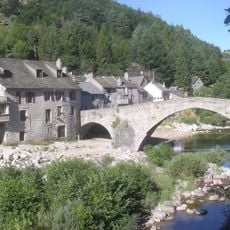
Pont de Montvert
7.5 km
Écomusée du mont Lozère
7.4 km
Gisement gallo-romain de Saint-Maurice-de-Ventalon
5 km
Église Notre-Dame-de-la-Salette de Saint-Privat-de-Vallongue
8.2 km
Signal de Ventalon
5 km
Mas du Viala Ponsonnenc
7.8 km
Association On the way to Robert Louis Stevenson
7.4 km
Église Saint-Étienne de Concoules
8.6 km
Bougès
7.4 km
Mine de plomb argentifère du Bocard
5.1 km
Temple de l'église protestante unie de France de Vialas
5.2 km
Temple de Saint-Privat-de-Vallongue
8.4 km
La Tete de Boeuf
5.4 km
Mont Lozere - Pic Cassini
5.4 km
Scenic viewpoint
7.4 km
Scenic viewpoint
6.6 km
Scenic viewpoint
5.4 km
Scenic viewpoint
5.4 km
Belvédère des Bouzèdes
6.5 km
Memorial, war memorial
8.4 km
Wayside cross
8.6 km
Aire à battre privée
7.4 km
Catholic church building, wayside cross
8.2 km
Memorial
7.7 km
Croix de Malte
4.9 km
Memorial
6.2 km
Memorial, war memorial
5.2 km
Commemorative plaque, memorial
6.7 kmReviews
Visited this place? Tap the stars to rate it and share your experience / photos with the community! Try now! You can cancel it anytime.
Discover hidden gems everywhere you go!
From secret cafés to breathtaking viewpoints, skip the crowded tourist spots and find places that match your style. Our app makes it easy with voice search, smart filtering, route optimization, and insider tips from travelers worldwide. Download now for the complete mobile experience.

A unique approach to discovering new places❞
— Le Figaro
All the places worth exploring❞
— France Info
A tailor-made excursion in just a few clicks❞
— 20 Minutes