Bunker
Location: Niederzissen
Operator: Heimat- und Kulturverein
GPS coordinates: 50.45723,7.22484
Latest update: November 20, 2025 01:10
Brohltal
1.9 km
Propstei Buchholz
2.4 km
Synagoge Niederzissen
309 m
St. Germanus
254 m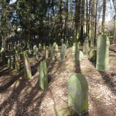
Jüdischer Friedhof Niederzissen
635 m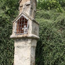
Wayside Shrine
2.6 km
Bausenberg
1.1 km
Vulkankuppen am Brohlbachtal
1.9 km
Brohltal-Schmalspureisenbahn Betriebs GmbH
608 m
Dreifaltigkeitskapelle
973 m
Wayside cross, Christianity, Catholic church building
136 m
Geysir-Blick
2.6 km
Scenic viewpoint
2.6 km
Johann Jacobs
526 m
Kaltwasser Geysir
2.8 km
1785
2.6 km
Catholic church building, wayside cross, Christianity
2.1 km
Catholic church building, wayside shrine, Christianity
208 m
XXL-Bank
2.1 km
Catholic church building, wayside cross, Christianity
1.6 km
Wayside cross
381 m
Wayside cross
1.3 km
Wayside cross
1.5 km
Catholic church building, wayside cross, Christianity
587 m
Wayside shrine, Christianity
1.7 km
Wayside cross
2.6 km
Memorial stone, memorial
2.1 km
Wayside cross
2.2 kmReviews
Visited this place? Tap the stars to rate it and share your experience / photos with the community! Try now! You can cancel it anytime.
Discover hidden gems everywhere you go!
From secret cafés to breathtaking viewpoints, skip the crowded tourist spots and find places that match your style. Our app makes it easy with voice search, smart filtering, route optimization, and insider tips from travelers worldwide. Download now for the complete mobile experience.

A unique approach to discovering new places❞
— Le Figaro
All the places worth exploring❞
— France Info
A tailor-made excursion in just a few clicks❞
— 20 Minutes