Nacheiszeitliche Wiederbewaldung
Location: Birken, Quellhöfe
Location: Bayreuth
GPS coordinates: 49.92432,11.58324
Latest update: October 11, 2024 03:35
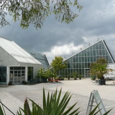
Ökologisch-Botanischer Garten der Universität Bayreuth
180 m
Binnendüne
103 m
Kalkalpen
162 m
Totholz
54 m
Schafweide
55 m
Kübelpflanzenfläche
108 m
Heidewäldchen
71 m
Feuchtheide
79 m
Wildwiese
80 m
Neophyten
86 m
Freiland-Aufzucht
90 m
Moore
98 m
Krähenbeerenheide
100 m
Callunaheide
52 m
Kalkmagerrasen
32 m
Arboretum
69 m
Fluss- und bachbegleitende Vegetation
112 m
Phänologischer Garten
113 m
Feuchtwälder
118 m
Küstendüne
121 m
Salicetum
127 m
Kleingewässer
141 m
Scenic viewpoint
152 m
Feuchtflächen
155 m
Europa
107 m
Prärie
175 m
Neophyten
179 m
Bienenhaus
28 mReviews
Visited this place? Tap the stars to rate it and share your experience / photos with the community! Try now! You can cancel it anytime.
Discover hidden gems everywhere you go!
From secret cafés to breathtaking viewpoints, skip the crowded tourist spots and find places that match your style. Our app makes it easy with voice search, smart filtering, route optimization, and insider tips from travelers worldwide. Download now for the complete mobile experience.

A unique approach to discovering new places❞
— Le Figaro
All the places worth exploring❞
— France Info
A tailor-made excursion in just a few clicks❞
— 20 Minutes