Schnapsbrunnen
Location: Ottenhöfen im Schwarzwald
GPS coordinates: 48.56696,8.17217
Latest update: November 24, 2025 02:48
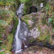
Edelfrauengrab waterfall
1 km
Bosenstein Castle
773 m
Oberes Achertal
713 m
Gottschlägtal, Eichhaldenfirst und Bosensteiner Eck
1.1 km
Eichkopf
1.1 km
Aussicht Köningerhof
1.2 km
Scenic viewpoint
370 m
Herrenschrofen
1 km
Scenic viewpoint
883 m
Scenic viewpoint
920 m
Scenic viewpoint
1.2 km
Brennte Schrofen
828 m
Scenic viewpoint
1.1 km
Schloßhof
884 m
Edelfrauengrab
996 m
Eichhaldenfirst
957 m
Königin des Friedens
1.2 km
Scenic viewpoint
559 m
Wayside cross
780 m
Zur Erinnerung an Wilhelm Kimming
966 m
Wayside cross
872 m
Wayside cross
963 m
Watermill
1.2 km
Wayside cross, Christianity
986 m
Wayside cross
826 m
Wayside cross
1.1 km
Waterfall
1.1 km
Wasserfall am Holderbrünnle
1 kmReviews
Visited this place? Tap the stars to rate it and share your experience / photos with the community! Try now! You can cancel it anytime.
Discover hidden gems everywhere you go!
From secret cafés to breathtaking viewpoints, skip the crowded tourist spots and find places that match your style. Our app makes it easy with voice search, smart filtering, route optimization, and insider tips from travelers worldwide. Download now for the complete mobile experience.

A unique approach to discovering new places❞
— Le Figaro
All the places worth exploring❞
— France Info
A tailor-made excursion in just a few clicks❞
— 20 Minutes