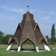
Betyárdombi tanösvény
Location: Táborfalva
Accessibility: Accesso limitato in sedia a rotelle
Website: http://turjanvidek.hu/?/tanosveny
Opening Hours: 24/7
Website: http://turjanvidek.hu/?/tanosveny
GPS coordinates: 47.06375,19.44249
Latest update: November 20, 2025 09:04
Geographical centre of Hungary
13.8 km
Euro-Ring
9.4 km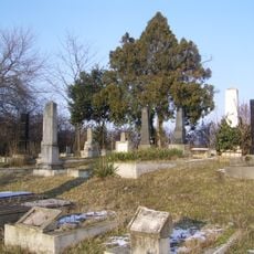
Jüdischer Friedhof (Örkény)
8.2 km
Magán ZOO
4.1 km
Magán-ZOO
4.1 km
Kettős-kereszt (49.)
8.2 km
Tormosi emlékkereszt
12.3 km
Coburg kastély
12.9 km
Bene falu árpád-kori templomromja és emlékhelye
5.3 km
Kunpeszéri Szalag-erdő Természetvédelmi Terület
8.9 km
Árpád-kor keresztje
8.7 km
Erdei Pihenőpark
10.9 km
Magyarország földrajzi középpontja (számított érték alapján, ld. forrás)
12.2 km
Pusztatemplom
9 km
Árpád-kori templom romja, Kunbaracs, XIII. sz.
8.7 km
Görögök homokja
10.4 km
Görögök homokja
11.1 km
Geréby-kúria
12.2 km
Geréby-kúria
12.2 km
Buckói Máriácska
9 km
Leány
9.8 km
Pásztor
9.7 km
Örkény Vitéz Szobor
7 km
Amatőrcsillagász észlelőhely (7,2mn darksky), Kunbaracs pusztatemplom
8.7 km
Amatőrcsillagász észlelőhely (6,7mn darksky), Pusztavacs-1
11.6 km
Amatőrcsillagász észlelőhely (7,1mn darksky), Pusztavacs-2
11.4 km
Amatőrcsillagász észlelőhely (6,74mn darksky), Lajosmizse Pusztatemplom
9 km
Scenic viewpoint, public swimming pool
9 kmReviews
Visited this place? Tap the stars to rate it and share your experience / photos with the community! Try now! You can cancel it anytime.
Discover hidden gems everywhere you go!
From secret cafés to breathtaking viewpoints, skip the crowded tourist spots and find places that match your style. Our app makes it easy with voice search, smart filtering, route optimization, and insider tips from travelers worldwide. Download now for the complete mobile experience.

A unique approach to discovering new places❞
— Le Figaro
All the places worth exploring❞
— France Info
A tailor-made excursion in just a few clicks❞
— 20 Minutes