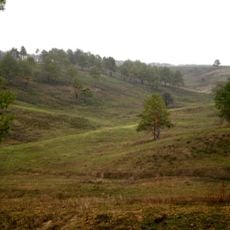
Знак у полі
Location: Феодосіївська сільська громада
GPS coordinates: 50.21637,30.45685
Latest update: November 15, 2025 00:19
Vasylkivski Karpaty Reserve
2.3 km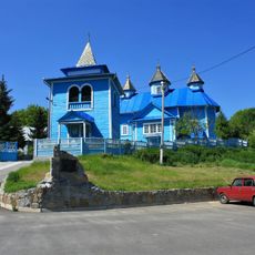
Saint Michael church in Pidhirtsi, Obukhiv Raion
6.1 km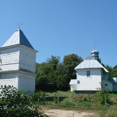
Church of the Intercession in Krenychi
4.4 km
DreamSky Observatory
6.3 km
Казковий яр
5.4 km
Долина річки Крушинка
2.6 km
Scenic viewpoint
5.6 km
Закатішна
5.5 km
Scenic viewpoint
4 km
Scenic viewpoint
6.7 km
Бугаївський яр
5.4 km
Бугаївські яри
5.2 km
Бугаївські яри
6.3 km
Scenic viewpoint
4.5 km
Іводзіма
6.2 km
Рославичі
3.4 km
Васильківські Карпати
2 km
Scenic viewpoint
6.1 km
Scenic viewpoint
5.2 km
Scenic viewpoint
4.9 km
Scenic viewpoint
5.1 km
Scenic viewpoint
5.7 km
Київське звалище в Підгірцях.
4.7 km
Scenic viewpoint
7 km
Scenic viewpoint
6 km
Scenic viewpoint
6.9 km
Супер пейзаж
2.9 km
Scenic viewpoint
2.6 kmReviews
Visited this place? Tap the stars to rate it and share your experience / photos with the community! Try now! You can cancel it anytime.
Discover hidden gems everywhere you go!
From secret cafés to breathtaking viewpoints, skip the crowded tourist spots and find places that match your style. Our app makes it easy with voice search, smart filtering, route optimization, and insider tips from travelers worldwide. Download now for the complete mobile experience.

A unique approach to discovering new places❞
— Le Figaro
All the places worth exploring❞
— France Info
A tailor-made excursion in just a few clicks❞
— 20 Minutes