Brushgrove Recreation Triangle
Location: Brushgrove
Location: Clarence Valley Council
GPS coordinates: -29.56638,153.07841
Latest update: November 22, 2025 13:24
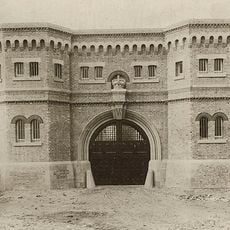
Grafton Correctional Centre
18.2 km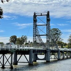
McFarlane Bridge
16.1 km
Fortis Creek National Park
15.7 km
Jaycee Park
17.8 km
Westward Park
18.9 km
West Ward Park
18.9 km
Doust Park
2.1 km
Tyndale Park
8.8 km
Jacaranda Park
18.4 km
Apollo 11 Park
18.9 km
Ryan Park
17.7 km
Wherrett Park
17.8 km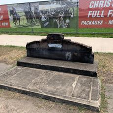
Horse trough
18.8 km
Everlasting Swamp National Park
5.4 km
Maclean Golf Club
12.8 km
GDSC Golf Course
19.1 km
The Pinnacle Rocks
17.9 km
Bat tree
16.6 km
Criterion Theatre
19.2 km
Lookout
19.1 km
The Pinnacle Rocks
17.9 km
Arboretum Lookout
14.9 km
Maclean Lookout
18.2 km
Lookout
18.4 km
Bicentennial Memorial Cairn
16.8 km
Cowper Memorial Garden
709 m
War Memorial
8.8 km
Ruins
12.7 kmReviews
Visited this place? Tap the stars to rate it and share your experience / photos with the community! Try now! You can cancel it anytime.
Discover hidden gems everywhere you go!
From secret cafés to breathtaking viewpoints, skip the crowded tourist spots and find places that match your style. Our app makes it easy with voice search, smart filtering, route optimization, and insider tips from travelers worldwide. Download now for the complete mobile experience.

A unique approach to discovering new places❞
— Le Figaro
All the places worth exploring❞
— France Info
A tailor-made excursion in just a few clicks❞
— 20 Minutes