Manja Shelter
Location: Glenisla
Location: Shire of Southern Grampians
GPS coordinates: -37.27681,142.27421
Latest update: November 22, 2025 23:56
Grampians National Park
13.5 km
Grampians
14.1 km
Rocklands Reservoir
17.8 km
Glenisla
8.5 km
Scenic viewpoint
21.8 km
Djibalara (Asses Ears)
21 km
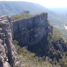
The Balconies Lookout
21.6 km
Scenic viewpoint
21 km
Scenic viewpoint
21 km
MacKenzie Falls Lookout
21.9 km
Wallaby Rocks
16.6 km
Scenic viewpoint
19.1 km
Burrong Falls
17.2 km
Paddy Castle
15.4 km
Cave of Emu Foot Aboriginal Shelter
8.7 km
Billimina Art Site
3.2 km
Scenic viewpoint
21.7 km
Scenic viewpoint
21.1 km
Scenic viewpoint
11.8 km
Reed's Lookout
21 km
Scenic viewpoint
21.7 km
Archaeological site
5.3 km
Buandik Falls
3.3 km
Waterfall
21.9 km
Waterfall
17.7 km
Burrong Falls
17.2 km
Fish Falls
21.9 km
Calectasia Falls
19.4 kmReviews
Visited this place? Tap the stars to rate it and share your experience / photos with the community! Try now! You can cancel it anytime.
Discover hidden gems everywhere you go!
From secret cafés to breathtaking viewpoints, skip the crowded tourist spots and find places that match your style. Our app makes it easy with voice search, smart filtering, route optimization, and insider tips from travelers worldwide. Download now for the complete mobile experience.

A unique approach to discovering new places❞
— Le Figaro
All the places worth exploring❞
— France Info
A tailor-made excursion in just a few clicks❞
— 20 Minutes