Devils Waterhole at Hickeys Falls
Location: Gilgandra
Location: Gilgandra Shire Council
GPS coordinates: -31.71076,148.67010
Latest update: October 26, 2025 22:32
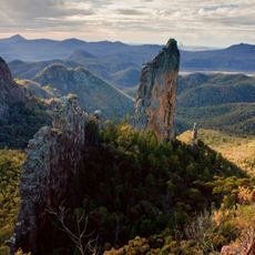
Warrumbungle National Park
58.8 km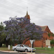
St Ambrose Church, Gilgandra
655 m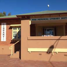
Gilgandra Library
2.7 km
Grinding Grooves
51.7 km
Spirey View Lookout
53.6 km
Western Plains Riding Centre
57.9 km
Gin gin weir camp
56 km
Royal Flying Doctor Service Visitor Education Centre
57.1 km
Solar System Drive - Uranus
35.9 km
Orana Cactus World
1.1 km
Two Eight Two Eight Gallery Cafe
46.4 km
The Returned Soldier
37.2 km
G K Rohr Warrumbungle Viewing Platform
37.2 km
Whitegum Lookout
58.2 km
Cathedral Arch
51.8 km
Macha Tor
54.2 km
Amphitheatre
1.7 km
Febar Tor
54.1 km
Breadknife Gap
52.4 km
Point Wilderness
52.4 km
Middle Spirey View
52.3 km
Dow's Lookout
52.1 km
Kurrajong Corner
52.3 km
Scenic viewpoint
51.9 km
Freeguards Prospect
51.5 km
Scenic viewpoint
52.3 km
Lugh's Throne
52.2 km
Scenic viewpoint
56.9 kmReviews
Visited this place? Tap the stars to rate it and share your experience / photos with the community! Try now! You can cancel it anytime.
Discover hidden gems everywhere you go!
From secret cafés to breathtaking viewpoints, skip the crowded tourist spots and find places that match your style. Our app makes it easy with voice search, smart filtering, route optimization, and insider tips from travelers worldwide. Download now for the complete mobile experience.

A unique approach to discovering new places❞
— Le Figaro
All the places worth exploring❞
— France Info
A tailor-made excursion in just a few clicks❞
— 20 Minutes