F. E. Sillanpään rintakuva
Location: Hämeenkyrö
Creator: Heikki Nieminen
Creator: Heikki Nieminen
GPS coordinates: 61.65013,23.18852
Latest update: October 25, 2025 02:52
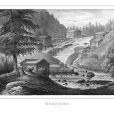
Kyröskoski
2.2 km
Haveri mine
7.3 km
티미의 소나무
3.9 km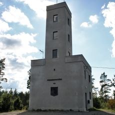
Mannanmäki observation tower
5.1 km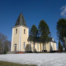
Hämeenkyrö church
1.6 km
Jumesniemi Church School
13.1 km
Myllykolu, F. E. Sillanpään syntymäkotimuseo
7.6 km
Viljakkala Church
7.9 km
Mäntyrinne chapel
3.6 km
The old cemetery chapel
2 km
Lehtiniemi
12 km
Rauhamaa
1.9 km
Lehtiniemenlahti
11.8 km
Kortesuonmäki
8.4 km
Sirkan metsä
10.8 km
Hiirenmäki
9.3 km
Kukkola
12.6 km
Pelttarinvuori
13.2 km
Ihantola
6 km
Yli-Raukola
6.2 km
Lahdenkallio
10.9 km
Silja-veistos
1.9 km
Sielu ja sielun koti
1.9 km
Malja & Kuhilas: Kuhilas
1.4 km
Malja & Kuhilas: Malja
856 m
Scenic viewpoint
12.6 km
Scenic viewpoint
10.7 km
Scenic viewpoint
11.4 kmReviews
Visited this place? Tap the stars to rate it and share your experience / photos with the community! Try now! You can cancel it anytime.
Discover hidden gems everywhere you go!
From secret cafés to breathtaking viewpoints, skip the crowded tourist spots and find places that match your style. Our app makes it easy with voice search, smart filtering, route optimization, and insider tips from travelers worldwide. Download now for the complete mobile experience.

A unique approach to discovering new places❞
— Le Figaro
All the places worth exploring❞
— France Info
A tailor-made excursion in just a few clicks❞
— 20 Minutes