Wilder Mann
Location: Geyer
Made from material: wood
GPS coordinates: 50.63216,12.86692
Latest update: July 20, 2025 15:49
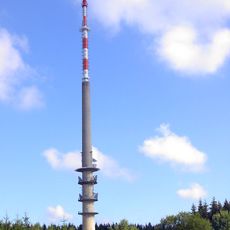
Sender Geyer
1.1 km
Greifensteingebiet
2.5 km
Buchberg
1.7 km
Steinbogenbrücke und Uferbefestigung Zwönitz
2.8 km
Wiese Galgenspitze
1.9 km
Gehölzkuppe II (Am Schäferberg)
2.7 km
Fledermausquartier
2.7 km
Quellgebiet Lehmbach
1.5 km
Börner-Teich
2 km
Waldbergbächel (Unterer Lehmbach)
2.5 km
Wiese am Buchberg
2.4 km
Schaalbrückenweg
2.2 km
Moorgebiet Rotes Wasser
1.6 km
Mühlgraben
2.8 km
Buchberg
2.1 km
Grenzstein
1.5 km
Rentzschwiese Geyer
2.7 km
Hoffmannsteich
1 km
Kommunestolln »Segen Gottes« Niederzwönitz
2.7 km
Gehölzkuppe I (Am Schäferberg)
2.6 km
Förster & Christel
2.3 km
Work of art, statue
2.7 km
Liedersteinweg
2.7 km
Burgstädtler Wasser
2.6 km
Heiligenhauser Ecke
2.5 km
Schaumeiler
2.7 km
Dreilagenstein
1.5 km
Königstanne
1.4 kmReviews
Visited this place? Tap the stars to rate it and share your experience / photos with the community! Try now! You can cancel it anytime.
Discover hidden gems everywhere you go!
From secret cafés to breathtaking viewpoints, skip the crowded tourist spots and find places that match your style. Our app makes it easy with voice search, smart filtering, route optimization, and insider tips from travelers worldwide. Download now for the complete mobile experience.

A unique approach to discovering new places❞
— Le Figaro
All the places worth exploring❞
— France Info
A tailor-made excursion in just a few clicks❞
— 20 Minutes