Kliever Rakete
Location: Anröchte
Accessibility: Accesso limitato in sedia a rotelle
GPS coordinates: 51.57177,8.29945
Latest update: November 24, 2025 02:05

Kloster Annenborn
2.2 km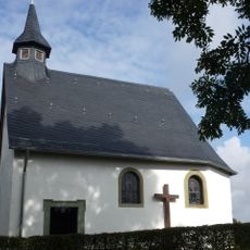
St. Anna
2.3 km
Talbereich des Sonnenborn-, Borns- und Welschbach
906 m
Güller Bach-Lobbenbach
2.2 km
Steinbruch nordöstlich Anröchte
2.3 km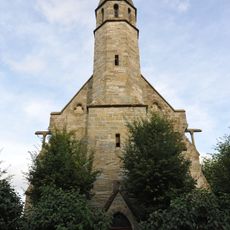
St. Vinzenz
780 m
LSG-Agrarbereich entlang der Sonnenborn, Welsch-, Bornsbaches
1.4 km
Ehrenmal
793 m
Hofkreuz
1.8 km
Work of art
740 m
Wayside cross
1.9 km
Wayside cross
864 m
Wegkreuz
2.3 km
Wegkreuz
813 m
Pfarrhaus
2.3 km
Wegekreuz
2.1 km
Wegekreuz
1.3 km
Wegekreuz
1.4 km
Alte Mühle
1.2 km
Bildstock
2.1 km
Wayside shrine
2.2 km
Hofkreuz
329 m
Hofkreuz
1.8 km
Kreuzstock
2.1 km
Wegekreuz
2.3 km
Wegekreuz
2.3 km
Wayside cross
495 m
Wayside cross
2.1 kmReviews
Visited this place? Tap the stars to rate it and share your experience / photos with the community! Try now! You can cancel it anytime.
Discover hidden gems everywhere you go!
From secret cafés to breathtaking viewpoints, skip the crowded tourist spots and find places that match your style. Our app makes it easy with voice search, smart filtering, route optimization, and insider tips from travelers worldwide. Download now for the complete mobile experience.

A unique approach to discovering new places❞
— Le Figaro
All the places worth exploring❞
— France Info
A tailor-made excursion in just a few clicks❞
— 20 Minutes