Parks
Location: Werther (Westf.)
Creator: Hinrich Schmieta
Creator: Hinrich Schmieta
GPS coordinates: 52.07291,8.41776
Latest update: November 22, 2025 14:28
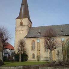
St. Jacobi Werther
276 m
Talweg
337 m
Werther Schanze
1.8 km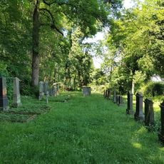
Jüdischer Friedhof (Werther (Westf.))
764 m
LSG-Sieke des Ravensberger Huegellandes
2.6 km
Osning
2.7 km
Treckermuseum
773 m
Parks (Terelje N.P.)
57 m
Scenic viewpoint
2.5 km
Freibad Werther
504 m
Parks (Herrenhausen)
83 m
Parks (Denver Col)
41 m
Parks (Central Park)
26 m
Parks (Imperial)
40 m
Weg für Genießer - Rastplatz "Riechen"
1.7 km
Bauernjunge aus Arrode
256 m
Sculpture, Work of art
132 m
Scenic viewpoint
1.9 km
Storck-Haus
306 m
Scenic viewpoint
1.8 km
Archaeological site
1.9 km
Archaeological site
1.9 km
Archaeological site
1.9 km
Archaeological site
1.9 km
Archaeological site
1.9 km
Archaeological site
1.8 km
Grabstätten Böckstiegel
476 m
Memorial
270 mReviews
Visited this place? Tap the stars to rate it and share your experience / photos with the community! Try now! You can cancel it anytime.
Discover hidden gems everywhere you go!
From secret cafés to breathtaking viewpoints, skip the crowded tourist spots and find places that match your style. Our app makes it easy with voice search, smart filtering, route optimization, and insider tips from travelers worldwide. Download now for the complete mobile experience.

A unique approach to discovering new places❞
— Le Figaro
All the places worth exploring❞
— France Info
A tailor-made excursion in just a few clicks❞
— 20 Minutes