Der Trauben naschende Hase
Location: Hatzenport
Inception: January 1, 2008
Creator: Peter Hänig
Creator: Peter Hänig
GPS coordinates: 50.22798,7.41872
Latest update: November 20, 2025 01:28
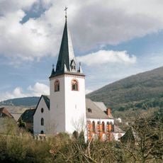
St. Luzia
2 km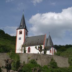
St. Johannes
376 m
St. Rochus (Church : Hatzenport, Germany)
41 m
Jahrs-Berg
1.7 km
Mittel- und Untermosel
1.6 km
Rabenlay
776 m
Wayside cross
908 m
Ehrenmal
1.8 km
Scenic viewpoint
1.7 km
Bench, scenic viewpoint
1.9 km
Scenic viewpoint, bench
1.8 km
Kreuzlay
325 m
Scenic viewpoint
1.9 km
Moselpanorama - Säßchen
448 m
Traubenkelter
1.6 km
Scenic viewpoint
760 m
QUAD - Venture
1.7 km
Kriegerdenkmal
328 m
Kreuzweg Station 6
1.9 km
Kreuzweg Station 5
1.9 km
Kreuzweg Station 4
1.9 km
Kreuzweg Station 3
1.8 km
Kreuzweg Station 2
1.8 km
Kreuzweg Station 1
1.8 km
Wayside cross
266 m
Wayside cross
140 m
Wayside shrine
449 m
Christianity, wayside shrine
423 mReviews
Visited this place? Tap the stars to rate it and share your experience / photos with the community! Try now! You can cancel it anytime.
Discover hidden gems everywhere you go!
From secret cafés to breathtaking viewpoints, skip the crowded tourist spots and find places that match your style. Our app makes it easy with voice search, smart filtering, route optimization, and insider tips from travelers worldwide. Download now for the complete mobile experience.

A unique approach to discovering new places❞
— Le Figaro
All the places worth exploring❞
— France Info
A tailor-made excursion in just a few clicks❞
— 20 Minutes