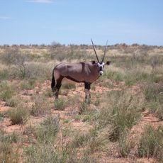
Dikbaardskolk Waterhole
Location: Mier Local Municipality
Website: https://tracks4africa.co.za/listings/item/w151132/dikbaardskolk-waterhole/
Website: https://tracks4africa.co.za/listings/item/w151132/dikbaardskolk-waterhole
GPS coordinates: -25.74410,20.72701
Latest update: November 18, 2025 05:34
Kgalagadi Transfrontier Park
34.5 km
Kalahari Gemsbok National Park
39.9 km
Khomani Cultural Landscape
35.9 km
ǀXam and ǂKhomani heartland
35.9 km
Nossob Rest Camp
38.2 km
Dikbaardskolk Waterhole
59 m
Nossob River Viewpoint
41.7 km
Jan se Draai Waterhole
22.9 km
Kransbrak Waterhole
32.6 km
Cheleka Waterhole
12.7 km
Kaspersdraai Waterhole
17.9 km
Marie se Draai Waterhole
33 km
Rooikop Waterhole
34.5 km
Nossob Waterhole
38.2 km
Dikbaardskolk Waterhole
2.9 km
Vaalpan Waterhole
34.7 km
Kameelsleep Waterhole
9.2 km
Scenic viewpoint
17.9 km
Marie se Draai Waterhole
33 km
Cheleka Waterhole
12.7 km
Scenic viewpoint
34.5 km
Dikbaardskolk Waterhole
2.9 km
Scenic viewpoint
22.9 km
Kameelsleep Waterhole
9.3 km
Kransbrak
32.6 km
Scenic viewpoint
15.3 km
Nossob Camp Hide
38.2 km
Kij Gamies Waterhole
42.3 kmReviews
Visited this place? Tap the stars to rate it and share your experience / photos with the community! Try now! You can cancel it anytime.
Discover hidden gems everywhere you go!
From secret cafés to breathtaking viewpoints, skip the crowded tourist spots and find places that match your style. Our app makes it easy with voice search, smart filtering, route optimization, and insider tips from travelers worldwide. Download now for the complete mobile experience.

A unique approach to discovering new places❞
— Le Figaro
All the places worth exploring❞
— France Info
A tailor-made excursion in just a few clicks❞
— 20 Minutes