Chest opened
+${chestReward.xp} XP
Explorer
NOUVEAU ×${chestReward.collectible.quantity}
tapez pour fermer
Chest locked

Open chests in the app

Around Us is built for your phone — chests unlock when you walk, explore and capture nearby places.

Enable Location

We need your location to show you interesting places around you

Discover nearby places

Find interesting locations and hidden gems around you

Precise directions

Get accurate directions and distances to places

Your location is never shared with other users. It's only used when you tap the location button.

Linia Środkowej Odry

Log in to your account

Start exploring — it's free

Trusted by 72,880 travelers worldwide

Continue with Google
Continue with Apple
or

We will send you a code to connect

By continuing, you accept our Terms and Conditions and our Privacy Policy

Check your inbox

We've sent a pincode in your inbox. Please enter the code below.

Discussion Reviews 2 Photos
3k Popularity

Linia Środkowej Odry, Befestigungslinie an der damaligen polnischen Demarkationslinie im Zweiten Weltkrieg

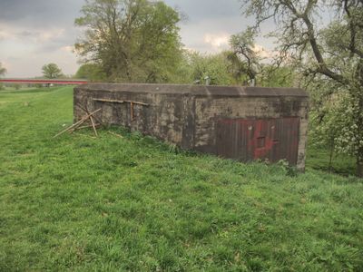
The Oderstellung is a series of about 650 concrete bunkers and defensive structures built between 1928 and 1939 along the left bank of the Oder River. The structures consist of individual concrete buildings with narrow entrances integrated into a flood embankment and designed for easy visitor access.

Construction began in the late 1920s and was completed around 1938, with soldiers continuously adding improvements. In the final phase of World War II, the line was reinforced again, and parts of it played a role in the fighting for Breslau between January and May 1945.

The name refers to its position along the Oder River as a defensive line. Today visitors can see how the site functions as a memorial to the region's military past and how the structures connect to local understanding of the area's history.

The site is open from June to October on the first Saturdays and Sundays of those months, with guided tours available by request. The structures are built into a flood embankment which allows easy movement around the various bunkers.

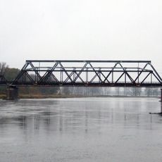
The Oder River itself was part of the defensive strategy, with bridges heavily guarded and mines laid to prevent crossings. Some bunkers, including objects 765 and 766, have been restored to show visitors how the structures originally functioned.

The community of curious travelers

AroundUs brings together thousands of curated places, local tips, and hidden gems, enriched daily by 60,000 contributors worldwide.

Start exploring
GPS coordinates
52.05679,15.42326
Latest update
February 9, 2026 08:23
Reviews
Share your experience

No review yet

Discussions
Start a discussion...

No discussion yet

« Linia Środkowej Odry - Befestigungslinie an der damaligen polnischen Demarkationslinie im Zweiten Weltkrieg » is provided by Around Us (aroundus.com). Images and texts are derived from Wikimedia project under a Creative Commons license. You are allowed to copy, distribute, and modify copies of this page, under the conditions set by the license, as long as this note is clearly visible.

Discover hidden gems everywhere you go!

From secret cafés to breathtaking viewpoints, skip the crowded tourist spots and find places that match your style. Our app makes it easy with voice search, smart filtering, route optimization, and insider tips from travelers worldwide. Download now for the complete mobile experience.

Around Us App Screenshot

A unique approach to discovering new places

Le Figaro

All the places worth exploring

France Info

A tailor-made excursion in just a few clicks

20 Minutes

Around Us
Travel Guide & Maps
Download

Send to your phone

QR Code
1

Open the camera app on your mobile.

2

Point at the QR code with your camera. A notification will appear.

3

Tap the notification to open the link.